PREPARATION FOR THE ASCENT
The team prepared for the ascent by means of trainings in Moscow . Before the ascent for the purpose of acclimatization we made reconnoiters to the bottom of the edge of the Peak Voennih Topografov and to one of slide-rocky saddles in the area of descent from the traverse.
To our great surprise the weather was quite fine we didn't have to sit in the camp. There was only few snow, all the glaciers were open. It was the first time we saw the glacier on approach to the pass – the beginning of the traverse open (when we held previous expeditions, it was completely covered with snow).
During walking days we were working for 5-9 hours, the relief below 5000 m was slide-rocky, above 5000 m –ice-snowy. The most difficult strips – horizontal rocky ridge on a way to the summit 5853, a strip 100 m long between the summits 5853-5960, ice fault 200 m on the descent from the plato 5700, several short strips of the 4 th -5 th grade of difficulty across bergschrunds, ridge with two-sided cornices on the descent to 5000 m , ice slope on the descent between ridges 320 m long, rocky ridge before the saddle on the descent. To work on the route we used 4 climbing ropes 45- 50 m long, 9- 11 mm in diameter, rocky hooks (we took some, but didn't use them), ice screws – 10 items.
Schedule of the ascent:
25.07 – approach from the Base camp to the pass
26.07 – passing easy part of the ridge and part of rocky faults
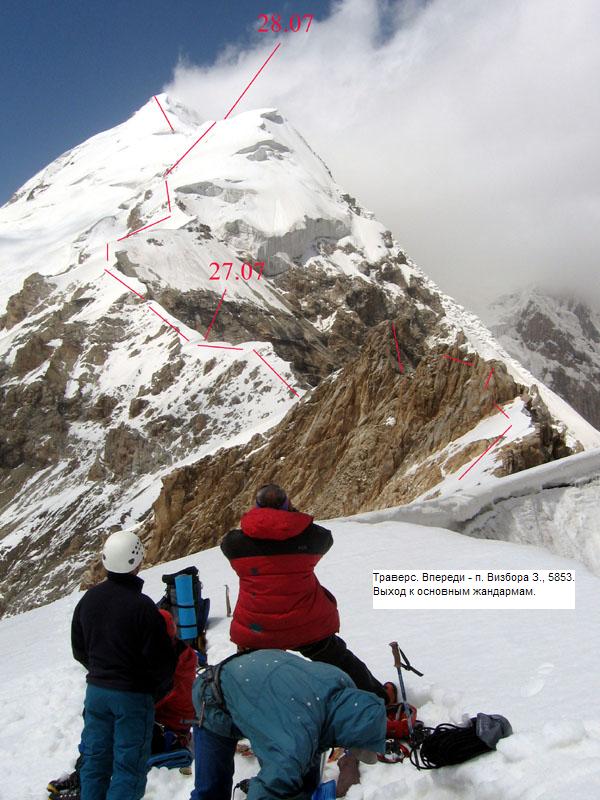
27.07 – passing rocky faults, mainly using fixed ropes. The weather was variable, cloudy, snow was falling.
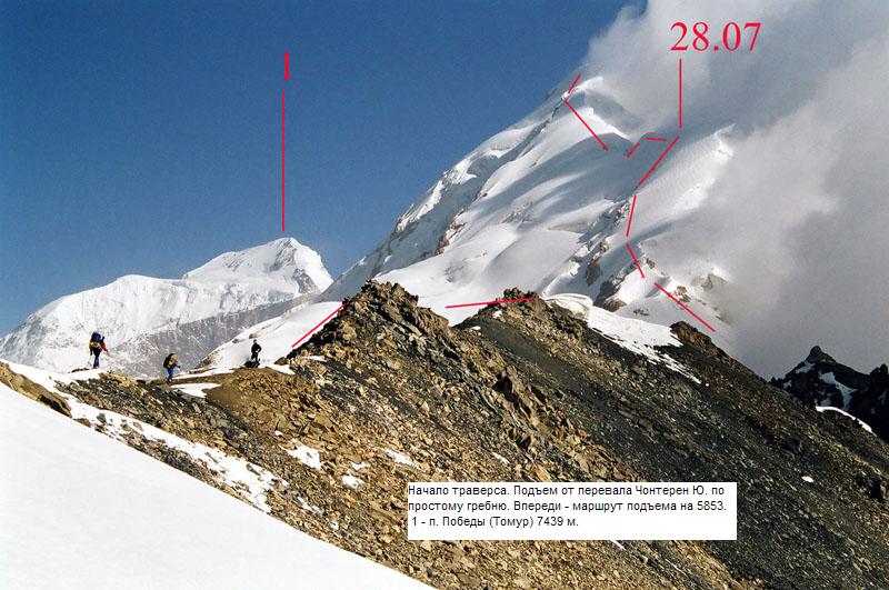
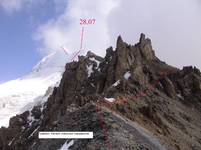
28.07 – passing steep strip of the ridge (using fixed ropes) up to the altitude 5300-5400. The weather was variable, cloudy, snow was falling.
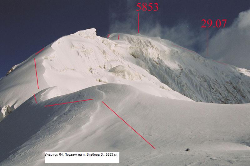
29.07 – climb to the summit 5853 (in two-man teams), descent down for about 100 m . The weather was variable, fog, snow was falling.
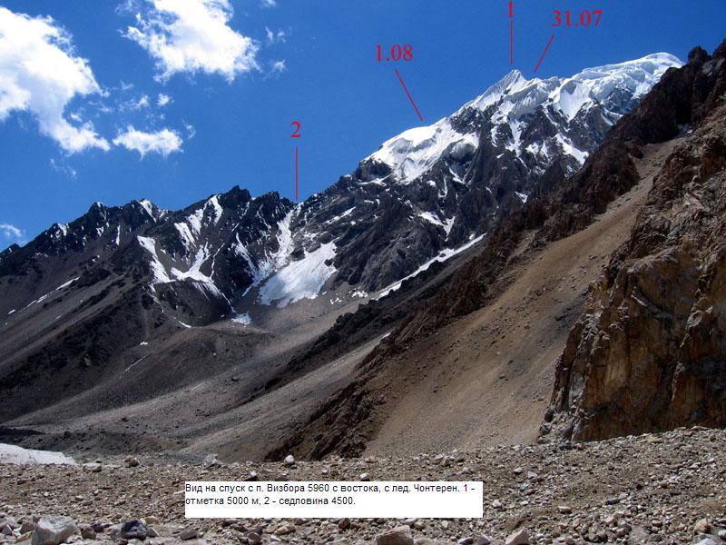
30.07 – wide ridge with cornices, with short difficult strips, climb to the Main Peak of the massif of Jury Vizbor 5960 m . Descent to the plato 5700m. In the morning very strong wind was blowing.
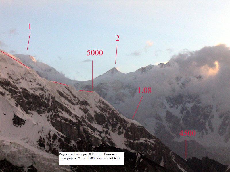
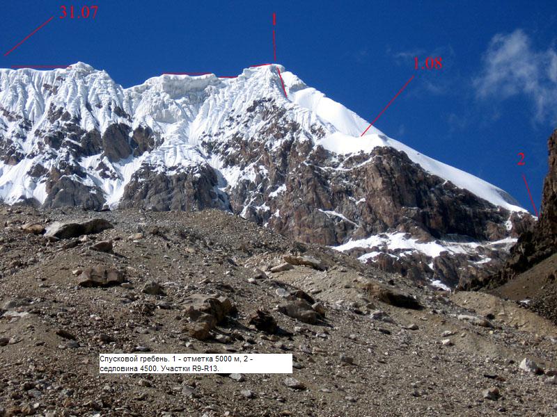
31.07 – Descent across faults to the altitude 5000 m , to the ridge with two-side cornices.
1.08 – passing the ridge with two-side cornices, descent along ice to the altitude 4800. Sun was in the sky for about 2 hours, then it was cloudy, snow was falling.
2.08 – snow-ice, further - rocky ridge. Working in two-man teams, sometimes fixing ropes. Descent to the saddle 4500 and further to the BC.
Strips of the route.
№ of the strip Short deion Extension in kilometers Grade of difficulty
R 0 Slide-rocky, further – snow-ice slope 0.5 2 of up to 30 degrees steep
R 1 Snow-slide-rocky ridge with rocky strips 0,5 2-2+
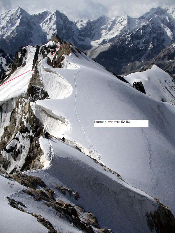
R 2 Detouring rocky faults – talus, conglomerate, rocky ledges, of 30-55 degrees steep, further snow slope of up to 45 degrees steep.0,3 2+ - 3
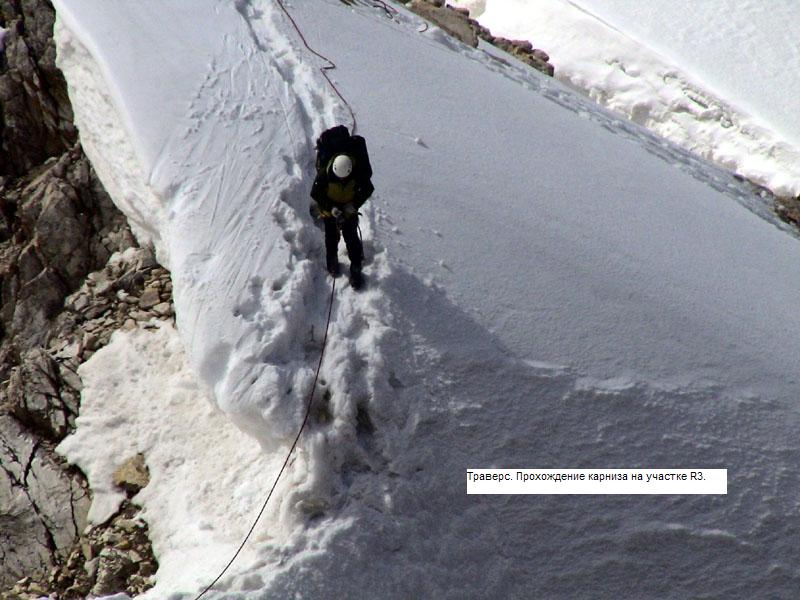
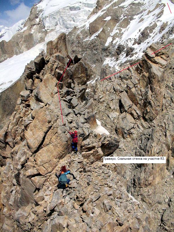
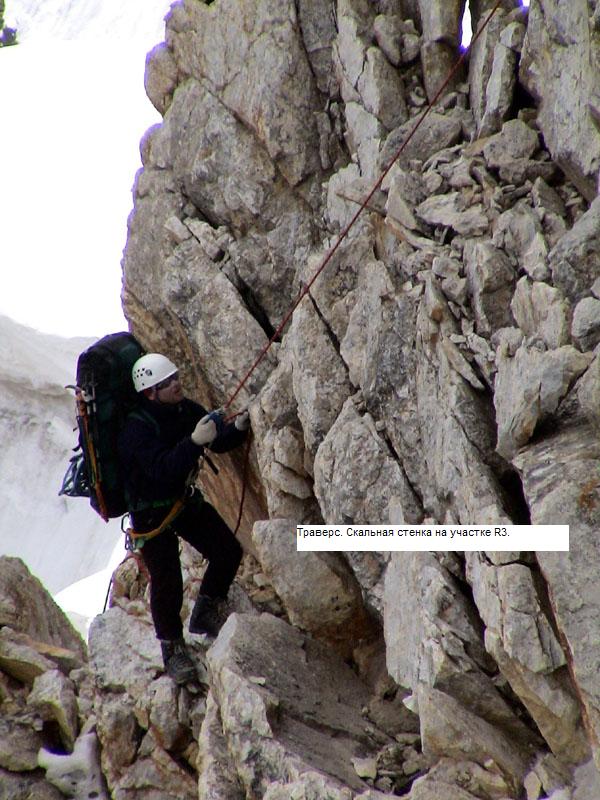
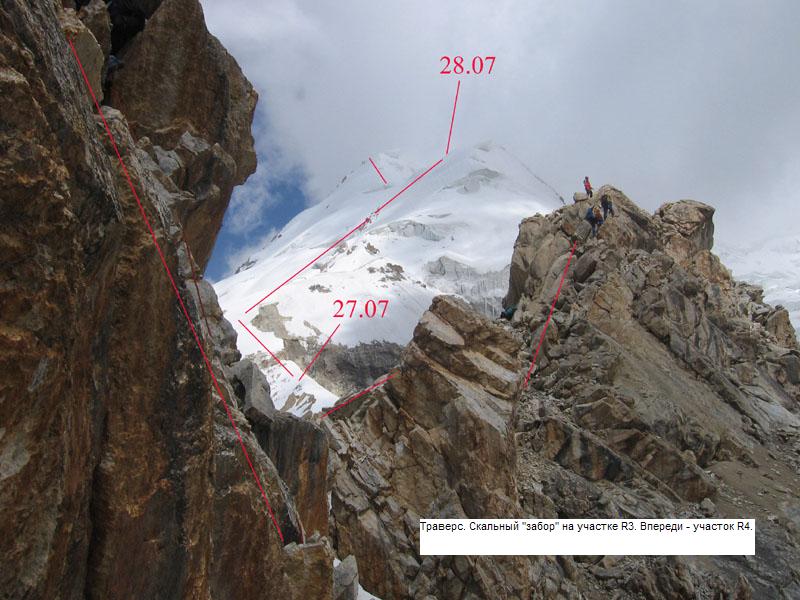
R 3 Rocky ridge, strips of snow-ice ridge with cornices, traverse 1.1 3+-4+
R 4 Snow-ice ridge with rocky outcrops of up to 50 degrees steep (rocky outcrops up to 90 degrees steep) 1.1 3+ - 5
R 5 Snow-ice ridge with cornices. Strips of 45-50 degrees steep. Traverse. 2.0 3-4
R 6 Snow-ice wide ridge with cornices, of up to 30 degrees steep, beginning of the descent/ 0.4 2+-3
R 7 Ice fault, of 100-70 degrees, all in all 200 m 0.2 5-5+
R 8 Snow-ice ridge – slope with bergschrunds, cracks, faults, of up to 45 degrees steep/ (on faults up to 90 degrees steep) 0.8 2+-4+
R 9 Ridge with two-side cornices 0.3 5-5+
R 10 Ice slope, diagonal descent, steepness 55-40 degrees (across the cornice – 15 m up to 95 degrees steep) 0.32 5-5+
R 11 Easy snow-rocky ridge up to the rocks 0.25 2-3
R 12 Rocky ridge of 40-50 degrees, with faults up to 80 degrees, destroyed 0.2 4-5
R 13 Easy slide-rocky ridge 0.15 1-2.
Deion of the route strip by strip.
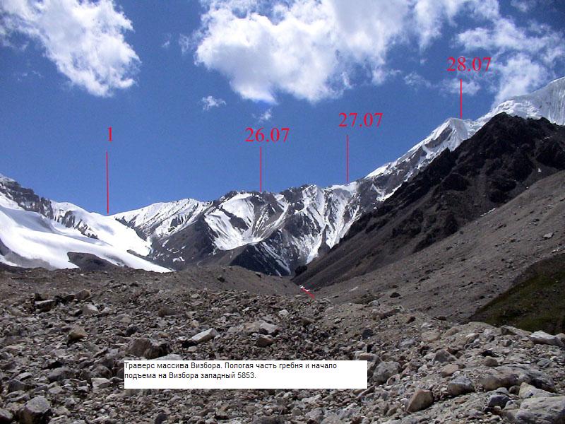
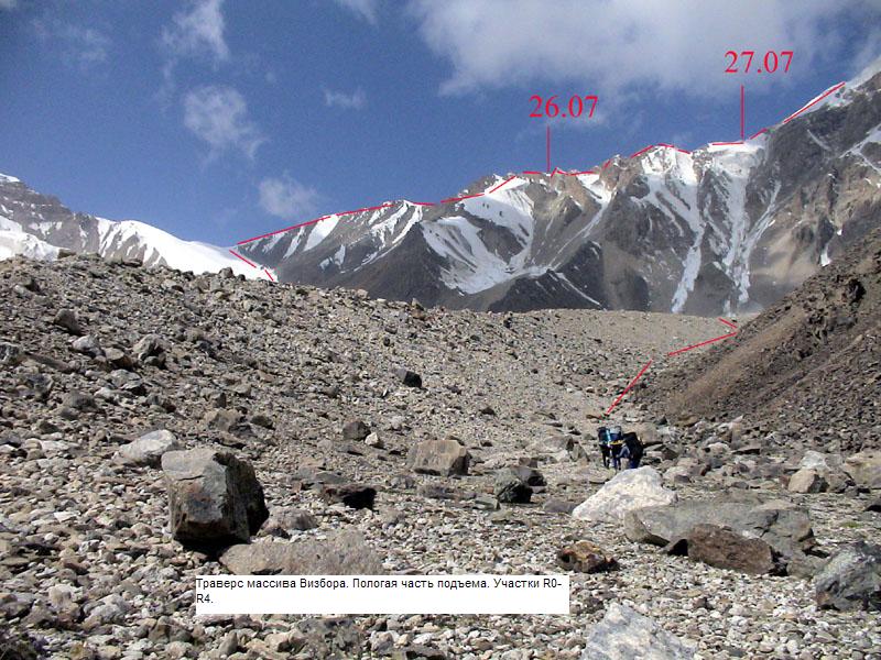
The first day, 26.07
Strip R 0. Climb to the pass. Slide-rocky moraine ridge to the right from the saddle, along the glacier, further snow-ice slope of up to 30 degrees steep.
Strip R 1. Easy snow-slide-rocky ridge with rocky outcrops, steepness – 5-15 degrees. Up to the beginning of cowstones – about 500 m .
Strip R 2. Rounding cowstones – screes, conglomerate, rocky ledges, steepness – 30-55 degrees, further snow slope of up to 45 degrees steep. Moving along the screes to the right of cowstones across the counterfort. Over the counterfort there was rocky-conglomerate slope, moving along ledges at the wall of 60-70 degrees steep, further along the screes to the next dock ridge, over it there was snow slope with avalanche gutter, along which we moved up to the ridge, rounding 2-3 big cowstones.
Strip R 3. Rocky and snow-ice ridge with cowstones, moving in teams, with the help of fixed ropes, passing the first part (about 200- 300 m ) up to the place for bivouac.
The second day, 27.07
Strip R 3. Rocky and snow-ice ridge with cowstones, passing the last part. There were different rocks, we moved up and down, mostly using fixed ropes, we belayed the first and the last members through juts, there were a lot of safe items.
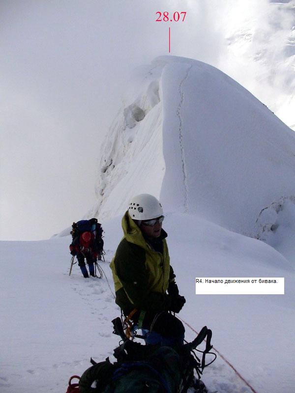
Strip R 4. Rocky and snow-ice ridge with rocky outcrops of up to 50 degrees steep. Short rocky wall of 2- 3 m high, of 90 degrees steep. Passing the bottom part with the help of fixed ropes, we had fastened on rocky outcrops, ice-axes, ice-screws. To pass the night we stopped in front of the wall (in 70 m ). (about 600 m ).
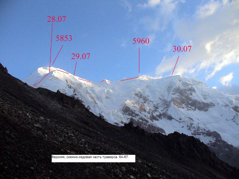
The fourth day, 29.07
Strip R 4. Snow-ice ridge of up to 45 degrees steep (upper part - about 500 m – climbing in teams).
Strip R 5. Snow-ice wide ridge with cornices. Traverse (going up and down). We passed the first part of the strip (went down to a place for passing the night)
The fifth day, 30.07.
Strip R 5. Snow-ice wide ridge with cornices. Traverse (going up and down), 30 m of fixed ropes on steep (up to 50 degrees) strip, sometimes alternate belay on cornices. Passing the last part of the strip.
Strip R 6. Snow-ice wide ridge, steepness – up to 30 degrees, we started to descend, went down in teams.
The sixth day, 31.07
Strip R 7. Ice fault of 100-70 degrees steep, all in all 200 m long. First two ropes were fixed on ice-axes, other – on ice-screws we went down with the help of descenders.
Strip R 8. Snow-ice ridge-slope with bergschrunds, cracks, faults, of up to 45 degrees steep (on faults – up to 90 degrees). Moving in teams, several ropes – going down with the help of descenders.
The seventh day, 1.08
Strip R 9. Narrow snow-ice ridge with two-side cornices, rounding the hole – going down along the slope of 50 degrees steep, 30 m , climbing for 20 m , along the slope of 70 degrees. Way down, up, and further after way up for about 150 m – we passed by fixed ropes, other parts of the strip – in teams.
Strip R 10. Ice slope, diagonal descend of 55-40 degrees steep (over the cornice – up to 95 degrees steep, 15 m ). Ropes fixed on ice screws at an angle 20 and more degrees to the right from the line of dip. On the sixth rope we crossed the ridge was to the right.
The eighth day, 2.08
Strip R 11. Easy snow-ice ridge up to rocks, moving in teams, before climbing along rocks – one fixed on ice rope, 30 m .
Strip R 12. Rocky ridge of 40-50 degrees steep, with faults up to 80 degrees steep, strongly destroyed. We rounded the fault to the left along rocky slope, descended with the help of descenders for 8 meters down along waterfall, went back to the ridge along screes.
Strip R 13. Easy slide-rocky ridge. Screes up to the saddle.
Tactic activity of the team.
Taking into account mistakes of the season 2004, that had frustrated passing Southern ridge of the Peak Voennih Topografov, we had chosen the most nearest to the summit object, acceptable according to its difficulty (although, frankly speaking, I thought it would be considerably easier). We planned to make a radial walk to the peak 5960 with two overnight stops on the altitude, similar to the altitude of the top. We had planned to ascent and to descend along long south-western ridge. But definitive decision about choosing the route we had put off to the beginning of the expedition.
We learnt all the variants during exploring we made while were waiting for our cargos (3 days). On the way to the Peak Voennih Topografov Vladimir and I looked through the south-eastern ridge of the peak 5960. It seemed to be not easy but acceptable for making an ascent, and for several kilometers shorter than south-western ridge. We decided to go up along it and to descend along long south-western ridge. The next day the rest part of our group went to a slide-rocky saddle in that south-western ridge (to the south from the saddle we would descend later). On returning to the camp they declared that it was impossible to climb up there as in the ridge there was a hole, rounding of which could be made along the wall, from which all the time stones were falling down. Four to two – and we turned back to original variant, having decided to make traverse with descend to south-east, if there however would not be a hole. Later as the guys became unable to point the hole from the opposite side, we made a full traverse. They had mistaken a 40-m high rocky fault we rounded to the left along rocks and waterfall.
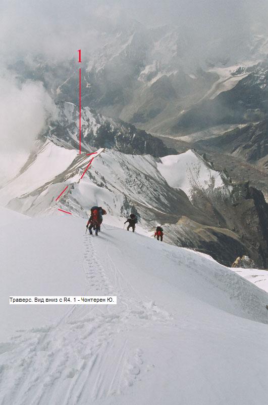
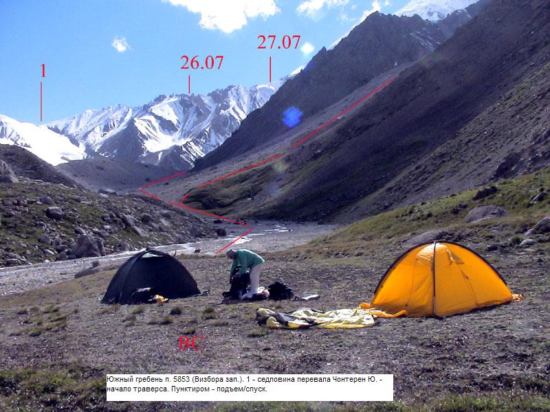
The pass from which we had began our traverse we named beforehand Chonteren the South. Probably it would turned out to be easy enough (now I hope it is of 1A-2Bgrade of difficulty, in the year 2002 I decided it was not easier than 3A) to use it for carrying cargos to the Southern wall of the Pobeda Peak . Not everything is clear now about the grade of difficulty of the pass as at the foot of it a slide-rocky couloir turns and goes to a canyon where cowstones can be found. If the pass is become easy enough – decision of the problem of the Southern wall can become more real. In 3 km from the saddle there was a beautiful summit 5853 m , on which we hadn't pay attention while preparing the expedition (I took it as summit 5960). When we understood the situation with summits, it turned out hat we could make a rather beautiful march or traverse of two summits – 5853-5960, between that there were about two kilometers. And as the year was declared the year of Jury Vizbor, we decided that nothing would happen with the Chinese if we would name one small peak after jury Vizbor. And we named it.
|
|
|
The ascent was held in such a way.
Approach. From the Base camp we went to the west, in the direction of the pass along the stream from the west confluent of the glacier Chonteren that flew in a wide slide-rocky pocket. In about1.5 km the pocket became narrower, rise started, we went to the top part of the glacier, then climbed to the left along the strike to a high moraine ridge, for some time went along the ridge looking for a flat strip to cross cased glacier (it was all in embarrassing hillocks). We crossed it (it was about two kilometers wide there) in the direction of the saddle of the pass, climbed to the right-side moraine ridge and went further along it. The ridge slightly turned to the south along small glacier, flowing from the saddle, slightly turning to slide-rocky slope with icy strips. We came to the bound of snow, where on the screes near the saddle made a bivouac.
|
|
|
The first day, 26.07.2006. We set off from the bivouac early and in 30 minutes along the snow climbed to the saddle. Further we went along the rather wide ridge, sometimes along the ice, sometimes – along the screes, crossing or rounding rare rocky outcrops. In hour and twenty minutes we went to a saddle on which we saw a farewell rock – “toe”. From the saddle serious cowstones started, that from below seemed to be slightly-sloping rocky ridge. First of them we rounded to the right, at first along the screes, and after the nearest counterfort - along the rocks. There we came across an unpleasant traverse for about 20- 30 m along the ledges on the wall, then we went along steep conglomerate slope that becoming slightly-sloping led us to the next ridge. On the ridge there was snow, that downwards went down steeply very soon, and upwards led to right from several cowstones back to the ridge, we went up to soon. The slope was melted a little and rather obnoxious, we went along the gutter of the avalanche went down from the bottom of the rock and further along the rocks – to the ridge. Further along the ridge we saw pointed cowstones, alternating with snow-ice strips with cornices. We were going most of the time in teams, sometimes with alternate belay/, there were short strips passed with the help of fixed ropes. In one of the places where the ridge became wide below a rocky strip and a comfortable trough was generated, we stooped to pas the night.
|
|
|
The second day, 27.07.2006. We went on passing cowstones. Further it was possible to move only over them as if there were roundings, they were with great number of senseless descendings from the ridge. Climbing over them was easy there were a lot of juts suitable for organizing belay, so it was unnecessary to use hooks. We almost didn't gain the altitude – went up – then down, up and down… the last member of the team take away the ropes by climbing without rucksack, on too steep descents using belay over juts with following running the rope through. In the afternoon we went to snow-ice ridge and some plications on it formed a nice place for bivouac. We made a camp there, having decided to fix ropes on the last for that day rocky wall in front. We fixed three ropes, they ended a little bit above the wall. The weather all the day long was variable, sometimes snow was falling.
The third day, 28.07.2006. The weather was cloudy, but visibility sometimes appeared. We went further, beside the wall the ridge was rather wide, of about 40-45 degrees steep. Rarely rocky outcrops could be found, on them we fixed ropes, on the ridge there was deep snow. Sometime snow began to fall from above. In such a way in a fog we passed about 15 ropes, near rocky outcrops the steepness grew up to 50-55 degrees. We went to a wide cornice, made a bivouac there.
|
|
|
The fourth day, 29.07.206. Sometimes something could be seen, sometimes snow fell, sometimes fog appeared. The ridge became something more slightly-sloping, we went in teams up to the top. To the summit 5853 we climbed at 12 o'clock according to Moscow time. Snow was falling. We built a place for notes somewhere below the cupola, left there a note – Peak Vizbora the Western. When it got clearer we descended to the first suitable trough as it started to blow (or, it could blow all the time but we went to the turning of the ridge, from as if from a cover). There we made a bivouac. Heavy wind was bowing all the night and morning long.
|
|
|
The fifth day, 30.07.2006. That time in front of us there was wide almost horizontal snow-ice ridge with cornices – climb between the summits – about 100 m , the lowest point f the strip – about 5650. But an the middle of the ridge there was a pointed snow-ice cowstone – I was the place where on the way upwards we used a fixed rope and just after it there was about two ropes of alternating belay – steep big cornices. The rest strip didn't present difficulties, it demanded only working in teams. We left the rucksacks in the place that seemed to be just below apical climb – from there it was clear way of traverse along the south-western ridge to a small plato – the beginning of the south-western ridge. But it didn't become easy to get the summit in 20 minutes – after that climb there appeared one more, then more… As a result we went to the top two hours later. The weather was not bad and we managed to take photos of an excellent view around. We turned back to our rucksacks and descended to the plato. It was not very late but we need to have one more night higher up – the altitude there was about 5700m. We made a bivouac.
|
|
|