|
|
|
|
|
 |
|
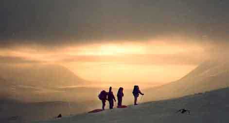
Mountain photos - amateur
and professional photos of mountains.
|
| Climb > |
|
Authors: Konstantin Beketov, Saint Petersburg, Otto Chkhetiani, Moscow
Southern
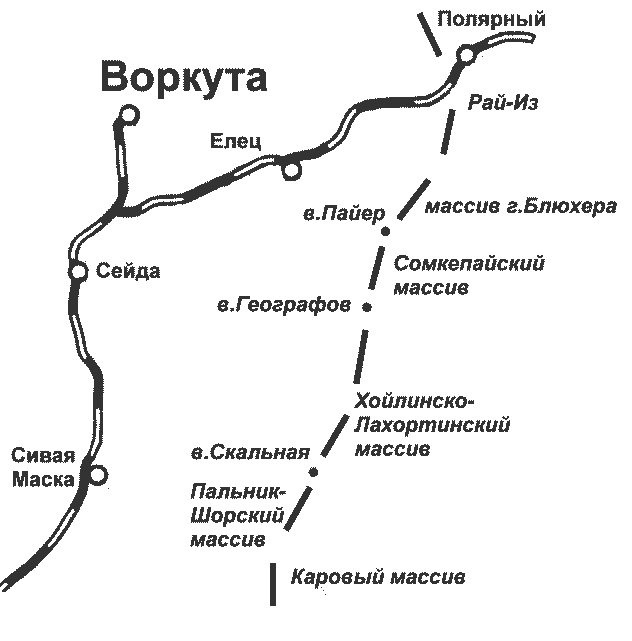
part of Arctic Ural Review of tourist opportunities of the area Part 1 Arctic Ural is considered the territory of Ural from the source of the river Khulga in the south up to Konstantinov Kamen's mountain in the north. In the west and the east ridges of Arctic Ural adjoin to taiga and tundra of the Pechora and Western - Siberian lowlands. The territory of Arctic Ural Mountain area takes more than 25000 km2.
According a character of the relief and its geological structure Arctic Ural splits into northern and southern sharply differing parts. A southern part of Arctic Ural (to the south from a valley of the river Sob) extends northeast by a narrow strip (up to 25-30 km in width) more than on 200 km. The range is divided by cross-section valleys into separate massifs: Ray-Iz, Makar-Ruzsky, Sobsky, Pay-Ersky, Somkepaysky, Khoylinsko-Lakhortinsky, Khordyuzsky, Palnik-Shorsky, Karovy, Kokpelsky. Absolute altitudes mountain chains reach 1100-1200 m and only separate tops tower 1400 m above sea level: Mt. Paier (1499 m), Mt. Blukhera (1427 m). Slopes of the range abruptly fall to foothill belt which separate foothill ridges of absolute altitudes up to 350-400 m (Maly (Small) Ural) from the foot of the mountains. Southern part of Arctic Ural presents both alpine and plateau-formed landforms. The Mountains here are strongly dismembered by deep gorges, valleys of the rivers and corries often filled with small glaciers. Valley downcuttings reach 600-800 m. In comparison with the northern parts of Arctic Ural the passes have much higher altitudes (400-1000 m above sea level) and ascent on them is more abrupt and longer. The first tourist visits to the southern part of Arctic Ural, as a rule, were limited by crossing of the range through one of low passes and trekking through the valleys aside the Arctic Ural railway station or Kharp railway station. When in 70th years good map-schemes of the mountain area appeared, tourists began to penetrate actively directly into mountains, to climb difficult passes, to traverse ridges and to include in a route technically sated sites: traverse of Paier's Pila (Saw), traverse of Paier and ascent on Mt. Skalnaya (Rocky).
By the end of 80th years the basic accent of tourist routes concentrated on technical routes in the area of massif Ray-Iz, closely adjoining to Labytnangskaya branch-line of Northern railway, and tourists campaigns throughout Paier area. Unstable weather in the area of Paier is the main reason that a lot of groups have appeared perfectly knowing neighboring tundra area, but have not summited Paier in fact. The best time for ski campaigns through the southern part of Arctic Ural is April. During a month usually 3-5 times snowstorm happens (for comparison: in February - about 10-12 times), duration of a bad weather seldom is more than one day. You can find below summary description of the area from Seyda-Labytnangi branch-line up to the Karovy massif, made on the basis of some reports and also own visiting the region. All the names are given according to a map of scale 1:100000, concepts "right" and "left" are used in the orographical sense, from numerous variants of names of passes and tops we chose the most often used ones. Massif Rai-Iz
Massif Rai-Iz is considered the extensive mountain terrain limited from the West by a through valley of the rivers Makar-Ruz and Sob; from the north and the east by the railway going through a valley of the river Sob; from the south by the rivers Engayu and Pokoinik (Dead man) - Shor. The highest points situated in the central part of the massif, in sources of the river Engayu reach 1130m. Ski tourists have already discovered more than 10 passes, graded from n/ń up to 2Ŕ. One of area's specialties is a canyon of a source of the creek Northern Nyrd-Vamen-Shor, where a cascade of ice falls are frozen in winter and you have to use climbing equipment to ascend it. The highest and the most interesting passes are located at the sources of the river Engayu: Grandiose (2Ŕ, 1150m, connects the left source of Northern Nyrd-Vamen-Shor with Engayu valley), Karovy (Northern Karovy) (1Ŕ, 1100m; leads from Karovy to the right inflow of the Sob river) and Neizvestny (Unknown person) (Southern Karovy) (1B-2Ŕ, 1100m; from Engayu to the other right inflow of the Sob river). Topographers Peak, a very beautiful mountain, is 2 km to the south. Its walls tower more than 500 m above a bottom of corries. The pass Trudny (Sportivny) (Difficult (Sports)), 1B, lays to the southeast. And to the south from the Northern Karovy pass a beautiful central top of 1259 m (peak Polar - 2Ŕ) towers. Mountain Chornaya (Black) (1013m) stands aloof to the south of the entire massif. Chorny (Black) pass (1Ŕ-1B, 844m) already climbed is in the western extremity. To the north of Mt.Chornaya on an extensive plateau Engayu-Iz an active base of geologists and a working mine are located. There is a desolate base of geologists in the valley of the creek Northern Nyrd-Vamen-Shor, but one inhabited hut still remains there. From all already climbed passes the Rai-Izsky pass (1B, 900m) is also worth to mention about. It leads through the plateau of Mt.Rai-Iz along the highest point. Rai-Iz massif is more often include in long routes, as a ring part of a campaign. And after it tourists tourist group bend their steps towards Khadata, or less often to the south to Paier. Sobsky massif It is extended 35 km from the pass Arka-Matalow in the south up to the railway in the north, and limited from the West by continental tundra, from the east - by the valleys of Sob and Makar-Ruz rivers. Sometimes within the limits of the territory Makaro-Ruzsky massif is separately allocated. The highest altitudes are concentrated in the northern part of the massif, in sources of the river Yelets (the highest point - 1236m). In the narrow northern part of the massif the pass Lekvozhsky is well-known (1B, connects sources the rivers Sob and Lekvozh). Ski tourists have already crossed some simple passes to the south. The most popular of them are two: Makar-Ruz (Northern Kuztyvis) (n/c, 500m, connects a source of the river Yelets with the river Makar-Ruz) and Kuztyvis (1Ŕ, 910m, leads from the river Yelets to a valley of Stepan - Ruz). To the south from Mt. Makar-Ruz (918 m) the range gradually loweres and the convenient passing from average current of the river Stepan - Ruz to a valley of the river Makar-Ruz is reconnoitered here - Lesnoy (Wood) pass (n/c). In the Bolshaya (Big) Kharamatalou river head the altitudes of the water-separate ridge do not exceed 600 m. Sobsky massif has no independent value. Blucher's massif To the east from submeridian line Lek-Khoila-Kharuta-Shor the extensive massif of Blucher's mountain (1427m) is located. The rivers Bur-Khoila, Bolshaya (Big) and Malaya (Small) Khara-Matalow originate from there. The northwest part of this plexus of mountains has distinct alpine character, in the area of the pool of the river Bur-Khoila the slopes get the smoothed outlines. There are 5 passes crossed there. Aziopa (Blucher) pass (1B, 1100m), connecting the right Kharuta-Shor river with a valley of the river Bur-Khoila, takes the central place. From a wide saddle of the pass it is easy to summit Blucher's mountain on a flat southern face's slope. From the north the summit's plateau abruptly breaks to the pass Matalow (High) (1Ŕ-1Á, 1100m), that connects the river Bolshaya (Big) and Malaya (Small) Khara-Matalow heads. A rocky ridge leads from the top northwest aside the pass of Arka-Matalow to West Khara-Matalow pass (1B). Peak Lokh (1376m) is 2 km to the east from Blucher's mountain. The high unnamed yet pass conducts from the left stream of the right head of the river Kharuta-Shor to the top corries of the river Lekh-Khoila. The pass is technically combined, about a 2A category. Winter traverses of the ridge leading from Blucher's mountain to Paier mountain are known. Blucher's massif strong lowers in northern direction to Arka-Matalow pass (n/c, 600m) where there is the Bolshaya (Big) Khara-Matalow river head. Burkhoilinsky pass (n/c) connects the rivers Malaya (Small) Khara-Matalow and Bur-Khoila heads. An extensive plateau, where Paity-Nel mountain (1156m) stands out, represents the East part of the massif. Northern slopes of the plateau are very abrupt; southern ones flatten out gradually lowering. Massif of Paier
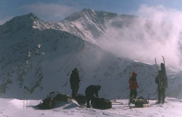
The highest point of Arctic Ural represents an interesting object for tourist pass hopping. Three main tops: Western (Southern) Paier (1330 m), Paier (1499 m), East Paier (1217 m) stand out. Mountain Paier represents sharply raised rocks with flat top. Relative altitude difference is 600-750 m. The separation of Paier's massif and the massif of Blucher's mountain adjoined from the east you can feel traversing Mt.Geographers and Somkepaisky's massif. It is visible, as on a background of flat and in general inexpressive ridges the extended rocky wall is sharply raised. Some variants of ascent on the top are known (technical complexity is specified for winter). The simple ascent route on Paier goes on the northern spur that splits the heads of the rivers Kharota and Right Ketch-Pel from a plateau of Sedlo (Saddle) pass (n/c, 825 m). In the beginning the wide ridge gets gradually narrowed and passes in sequence of simple gendarmes, the part from which you have to bypass on an abrupt western slope. It represents the main ascent difficulty. The complexity of ascent is 1B-1B*. The easy enough but sometimes avalanche dangerous route goes on couloirs of southwest face, the steepness of ascent does not exceed 35-40 degrees on its cruxes. It is the fastest route of 1B-1B* graded to ascend from the Kech-Pel-Ty lake up to the summit plateau and under favorable weather conditions it takes 1,5-2 hours. There are a few a little more difficult routes that lead from the passes Northern, Western - Paier and East - Paier (all of them are 2Ŕ-graded, and the last from listed above is objectively more complex and extended than the other ones). A range extended 20 km to the south begins from the top and splits valleys of the rivers Lek-Hoila and Left Paiera. There are 3 passes already climbed there: Lek-Hoila (2Ŕ, 1120 m), Spartak (1B, 1025 m) and Uspeshny prokhod (Successful pass) (1B, 835m). Lek-Hoila pass connects the upper lake in the valley of the river Lek-Hoila with the upper Left Paiera valley a little higher than the place where the powerful rock bar partitions off the entire valley from side to side. A crux of the ascent route is rocky site in the top part of the east slope where you have to fix the rope to ascend further. Descent route to Left Paiera is simple enough, but there are a lot of stones there. Spartak pass is located between a plateau of 1132 m and a 1110 m peak, The route of its ascent starts from Lek-Hoila and passes via a southern edge of a corrie located to the north from 1042m peak. The descent route leads to the creek valley of the inflow of the Left Paiera river. The falls in the bottom part of the creek valley can be bypassed on the right slope. Uspeshny prokhod pass (1B, 835m) is located between Verkhnaya (Top) Paiera peak and 978m peak (descent in Left Paiera was described earlier in old description and passes on the most right creek along the landmarks, established on the plateau). To the south the range sharply goes down to the Bur-Khoila. The high rock bar partitioning off the valley in two km lower than the headwater is a object of interest in Left Paiera. In spring a grandiose ice-falls of about 150 m rushes down the ledge. It's bypassed going along the left valley slope via snow couloirs. Paier can be bypassed through passes Severny (Northern) (1B, 1000m), Western - Paiersky (1B, 1000m) and East - Paiersky (1B, 940m). Western - Paiersky is the most popular of them. It connects a valley of Left Paiera and the lake of Kech-Pel-Ty. Severny (Northern) pass leads from a valley of the river Kharuta to the rocky cirque of the left source of the river Kharuta-Shor, and East - Paiersky - from this cirque to the south in a valley of the river Lek-Khoila. All these passes have enough abrupt slopes. You have to put on crampons passing them. To the southwest from Western - Paiersky pass a beautiful rocky top of Western Paier (1B, 1330m) towers. There are some variants of the ascent routes graded from 1Ŕ via a northwest ridge from a valley of the river Sredny Kechpel up to 3Ŕ via the northern face. The 15-kilometer ridge separates Left Paiera from its right source - the river Yambotyvis leaves to the south from there. The first 1.5 km of the ridge (from the top up to the plateau 1091m) represents a narrow rocky crest with powerful gendarmes (so-called "Pila Paiera (Paier's Saw)") - the complexity of traverse of the ridge reaches up to 3Ŕ. Between Western Paier peak and the gendarmes there is a saddle of Pila Paiera pass (1B, 1200m). Further to the south the ridge gradually extends in a number of a plateau with the highest altitudes: peaks 1115m, 950m and 880m. In the area of 950m peak there are located two nearest passes Levopaiersky (1Ŕ *, 880m) and Kechpelsky (1Ŕ *, 920m) leading to the north. The first one conducts from a valley of the river Left Paiera to the river Right Kechpel, the second one - from the river of Right Kechpel to the sources of the river Yambotyvis. More complex descent from the saddle plateau to the river of Sredny (Average) Kechpel is possible. |
| © 1999-2007 Mountain.RU Mail to: info@mountain.ru |
|