Добро пожаловать !
Войти в Клуб Mountain.RU
Mountain.RU

newsclimbski & snowboardadventurephotossearch

russian

Mountain photos - amateur and professional photos of mountains.
Climb >
Author: Pashuk Evgeny, Makhachkala.

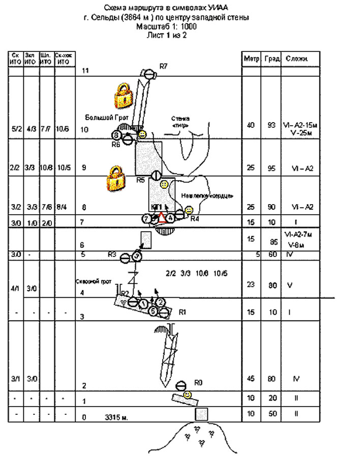
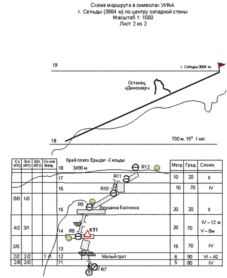
Mount SELDI (3664 m) along the center of the western wall
The ascent was made by the team of Dagestan State University.

The route had never been passed before. Passport of the ascent.

  1. Region 2.10, the Caucasus, Dagestan Mountains, canyon of the river Chehichai.
  1.  Seldi, 3664 m, 5 B grade of difficulty, along the center of the Western Wall.
  1. 5 B grade of difficulty is attended route was passed for the first time.
  1. Character of the route: rocky.
  1. Elevation change of the route: 350 m,

Extension of the route: 970 m,
Elevation change of the wall: 250 m,
Extension of the wall part of the route: 265 m,
Average steepness of the route: 75 degrees,
Average steepness of the central part of the wall: 83 degrees (from R2 to R8),
Extension of the strips of V grade of difficulty – 65 m, of VI grade of difficulty – 80 m,
We passed 80 m, using self-made points of rest, of A1 grade of difficulty – 0 m, of A2 grade of difficulty – 80 m, of A3 grade of difficulty – 0 m,
Including the strips passed with sky-hooks – 30 m.

     6.   Hooks, we left on the route: 9 items,
Rocky – 4 items,
Removable bolts – 1 item,
Stationary bolts – 4 items,
Holes for removable bolts (8 mm), we left on the route – 26.

  1. Points for belay we used: total/including used as self-made points of rest - 84/45.

Rocky hooks - 33/12
Hexcentrics - 25/12
Bolts - 26/21
Among them stationary bolts - 4/0
We used sky-hooks (times) – 28
We used self-made points of rest (times) – 73.

  1. We were working on the route for 32 hours, for 4 days,

 The leader was working on the route for 28 hours.
Including preliminary processing – 2 days, 11 hours.

  1. Nights we passed, working on the route: the first and the second were passed in ABC in tents under the wall (3050 m), the third was passed in “grotto”, it was sitting one (3395 m).
  1.  The leader: Pashuk Evgeny – advanced alpinist

Participants: Nurbagandov Gadzhimurad, Mazanov Tagir.

  1. Trainers: the team prepared on its own.
  1. Preliminary processing: 01.07.2004 – 02.07.2004
  1. We come to the route on 03.07.2004

Reached the top on 04.07.2004
Turned back to the BC on 04.07.2004.

      14. Organization: Dagestan State University.

        
REVIEW OF THE REGION OF ASCENT.

Seldi 3664 m along the center of the Western wall.

Mount Seldi is the highest point of the Western plateau of the massif Eridag - Iarudag, located in the Northern-Eastern spur of the Main Caucasus Range, at the border between Russia and Azerbaijan. The spur itself forms almost indivisible plateau with the mountains Iarudag and Shehdag, located in Azerbaijan. The western plateau of the massif ends with a wall, falling down to the canyon of the river Chehichai it forms the western part of the wall of the Mount Eridag (3925 m), stretching as an indissoluble arch for 15-km from the pass Gil in the NW to the pass Kurushsky in the South. Walls of 300-1100 meters high fall down to Dagestan. The wall is built of metamorphized limestone. Climate in the region is droughty, the most part of precipitations fall in May-June. In winter the weather is frosty and dry with periods of strong winds and abundant precipitations. There is one big problem: absence of water on the wall, it is possible to come across it even in winter.
You can come to the region of the ascent from the city Makhachkala along the federal route “Caucasus”, driving to the south to the settlement Novo-Goptsah (180 km), further turn to the right, go on driving up along the river Samur to the settlement Usuhchai (county town of Dokuzparinsky region) (225 km, 700 m). Then turn to the left, drive along earth road up along the river Usuhchai to the settlement Kurush (250 km, 2500 m). This way takes 6-8 hours. From the settlement Kurish go down along the path to the place where the river Seldi flows in the river Chehichai (2250 m), to the right at the left-bank terrace there is the tourist center “Eridag” of Dagestan Republic Search Rescue Service of the Russian Emergencies Ministry (30 min). It is possible to round it by car.

Approach to the route.

From the tourist center “Eridag” across two bridges you should turn to the right-bank terrace of the river Seldi. Further you have to go up along the road along the river rounding the green dome-shaped mount up to a deep slate nick with a stream. Then you should cross the stream and move along the path in the direction of the waterfall Charaur, leaving the ridge, going from under the waterfall, to the left. The paths lead you to the farm. You should cross the stream, flowing to the right from the farm and move up straight in front of the center of the Western wall of the Mount Seldi with a characteristic vertical interior angle.  There are many suitable areas but water can be found only in the springs at the farm level or near the waterfall. It is better to climb to the last ascent, ending with screes. There is a spring in 50-60 meters down along the screes. Under the characteristic red boulder with black vertical stripe there is a comfortable area – overnight stop “Red Stone”. The altitude there equals about 3100 m. Way there from the tourist center “Eridag” takes 2-3 hours. From overnight stop you have to climb vertically up along the screes to the interior angle of the wall. There is a comfortable protected ledge – beginning of the route.
The route goes along the center of the western wall of mount Seldi, along the most extensive and steep part of it. In spite of comparatively small extension of the wall part of the route (265 m), because of its high steepness and difficultness, it requires from the team full set of technical and tactical skills, and also perseverance and hope of victory.

Tactic of the ascent.
Mount Seldi 3664 m high along the center of the western wall.

Relying on longstanding observations of the route, reconnaissance marches and experience of attempts of passing the route, we chose following tactic of ascending: setting for processing and passing the route had to be performed from the overnight stop “Red Stone”. We planned to bring equipment and water to a wide ledge (R1-R2).
Processing of the route up to the station R5 or R6 (3 ropes) included bringing equipment and water. On passing the strips, through which stones can fall – ledges R0, R1-R2, chimney and cornice R6, the group has to be amassed at the corresponding station.

Tactic of processing:

Passing the strip R2-R3-R4:
Two-man team passes the strip with a minimum of equipment. The main equipment and water is located in the niche to the left from R2. After organizing the station R3 the second member takes station R2 away, comes to the station R3 and takes the fixed rope out. After the first member passes the strip R3-R4 and organizes the station R4, the second member takes station R3 away, comes to the station R4 and takes the fixed rope out. Then the rope is fixed straight from R4 to R1. In such a way it becomes unnecessary to pass diagonal fixed ropes with rucksacks and it rockfall becomes less dangerous as the members of the team are protected by big cornice. The third member brings equipment and water left on the ledge from R1 to R4, and then turned back down to R1.

Passing the strip R4-R5-R6:
Passing the first key strip is broken into two parts. As free climbing along overhanging wall is embarrassed and dangerous, passing all the wall long up to the grotto can require unreasonable amount of bolts. There climbers have to move from the right to the left to round overhanging wall. In order to reduce danger of falling rocks the second station is planned to be organized in the bottom of a stone “Heart”. After organizing hanging station by the first member of the team, the second member passes the strip R4-R5 without rucksack, straightening fixed rope, then he goes down using descender to the ledge R4. After passing the strip R6 by the first member of the team, he organizes under the cornice of a big grotto station R6 and goes down to R5, taking intermediate hooks away. The point of attaching fixed rope R5 is left for reducing the danger of rockfall.
There processing of comes to an end. Along three almost straight ropes the team descends from R6 to R0 and further to ABC. As a result of processing three vertical ropes hang on the wall and almost all the equipment is brought to the second ledge.

Tactic of making the ascent:

The whole group set off from the BC early in the morning. When passing the fixed ropes, the leader goes without rucksack and with belay. Other members go with blinding belay. The team gathers in a grotto R6, covered from falling stones. You have to start working on the second key strip R6-R7 (hanging interior angle) not later than at 10 o’clock a.m. If there are any unforeseen difficulties, it is necessary to make an overnight stop in the grotto. It is necessary to come to the plateau not later then at 8 o’clock p.m. It is possible to come to the top and to descend from it in twilight.
The group managed to complete its main mission.


Поделиться ссылкой

© 1999-2007 Mountain.RU
Mail to: info@mountain.ru
Рейтинг@Mail.ru Rambler's Top100