|
|
|
|
|
|
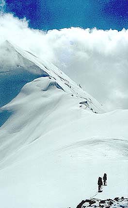
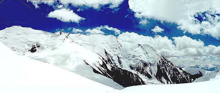
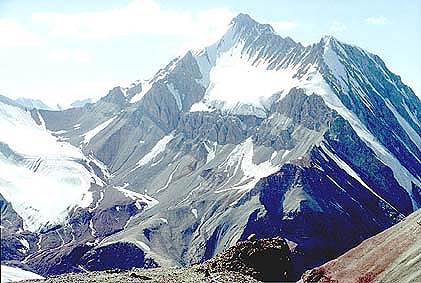
Mountain photos - amateur
and professional photos of mountains.
|
| Adventure > |
|
The author: Alexander Novik, Moscow
A campaign across Unknown Pamir Thread of the route: Karasu river - Transportny pass (1Ŕ, 4200) - East Kyzylsu glacier - "Vorota Nury (Nura's Gate)" pass (2Ŕ, 4800) - "Chetyrekh Mandarinov (Four tangerines)" pass (2B, 4700) - traverse 4812 peak (2B) - Nura glacier - traverse Zarya Vostoka (Dawn of the East) peak (3B, 6349) - East Kyzylsu glacier - Alexander Zotov's pass (3B, 6015) - Chorku peak (6283, radial) - Markansu pass (3Ŕ, 5800) - traverse 5917 peak (3Ŕ) - a settlement of Sarytash. All of them, except for Transportny pass (1Ŕ), are gone for the first time. Introduction
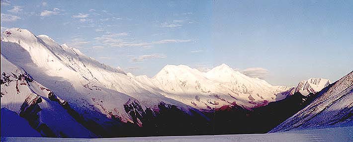
East part of Zaalaisky range or East Zaalai is called the ridge site to the east of Kyzyl-Art pass. These mountains are visible very well at entrance in Alaiskaya valley from descent from Taldyk pass and from the settlement of Sarytash. Geographically it is the most east part of Zaalaisky range - to the east of the pass through which Pamirsky Tpakt (Road) conducts from Osh to Pamir (i.e. much more to the east of Lenin peak, on the border with China). The most remarkable mountains of the area are distinctly looked through: Zarya Vostoka (Dawn of the East) peak (6349m), Kurumdy (6613m), Pogranichnik (Frontier guard) peak. The mountain ridge is under a significant congelation and on the outlines it reminds a site of Zaalaisky range to the east of Lenina peak. Up to the summer of 2000 all this 70-kilometer site of the mountain ridge remained practically unexplored, anyway, we possessed a trustworthy information only about V.Sokolenko's (Tomsk) campaign. He made an acclimatization ring route in the area of Pogranichnik (Frontier guard) glacier (all passes of the ring were not more complex than 2A) before the campaign in the central part of Zaalaisky range. Besides we got the information about the ascent on peak Markansu (6013m) in 1932. Thus, our travel was planned as one big first ascent. Originally the campaign was planned for a summer of 1999, but for a variety of reasons it was postponed. The Mountains of East Zaalai are naturally shared on two subdistricts - vicinities of Nura glacier and mountains of East Kyzylsu glacier and the area to the west. The Mountains of Nura glacier, such as Erkeshtam, Korumtortag, 5715 peak are sharper in comparison with their east neighbours. The possible ascents on the main ridge from Nura glacier with more abrupt slopes also demand significant technical efforts. All of variants available of ascents here are of 3-category (ice). The passes through the main ridge of the area of East Kyzylsu glacier have more flat slopes for ascent from the north. And on the average it a little bit higher and on character reminds passes of Zaalai ridge in its part to the east of Lenin peak, such as Kyzyl-Agyn, the Soviet Latvia, Edinstva (Unity), etc. Apparently, the biggest glacier of East Zaalai is Kurumdy glacier. Almost all its inflows, which are flowing down from the main ridge, break to Kurumdy with ice falls. In long northern spurs of East part of Zaalai range there are a lot of passes (1B - 3Ŕ) have been not gone yet. Ascents on the summits of northern spurs, such as peaks Pogranichnik (Frontier guard), 5468, Belyi (White) can represent the great interest. Though in the majority of valleys of East Zaalai there are no tracks almost all of them are easily passable, except for inflows of Nura where small "foot" complexities are possible. The climate of the area, generally speaking, is dry and steady, typical for Pamir. At the altitude about 3000m average temperature in July is 14-15 degrees. At the altitude more than 5000m you can be ready to negative 15-20 degrees. In the middle of August two - three-day period of bad weather usually takes place It is necessary to note, that during our campaign the steady bad weather held, and besides the locals assert, that the steady good weather in mountains have not been present for 2 or 3 years. Administratively the area belongs to Kirghizia, in area of Nura glacier on the main ridge the boundary with China passes, and with Tadjikistan - in area East Kyzylsu. The situation is quiet and stable. The local population is concentrated on frontier posts in Nura and Bordoba. You have to have a permit for travel to the area. Technical data:
20.07-21.07 transfer Bishkek (railway station)– Osh (by plane)- Alaiskaya valley (by vehicle). A bivvy at 3700m (?). The first full carry. 22.07- 24.07 Transportny pass (1Ŕ, 4200) The simplest way on a glacier East Kyzyl - Su runs through the pass in the northern spur of the main ridge as the river from under East Kyzylsu glacier flows in a deep conglomeratic canyon. Ascent on the valley of the East Kyzylsu River is inconvenient for the lack of water. The pass is simple - ascent from the West is absolutely flat, descent is on talus, rather abrupt and extended slope. 25.07- 26.07 Pass “Vorota Nury (Nura's Gate)” (2Ŕ, 4800) The pass connects the glacier flowing down from the peak 5368 on West and the glacier flowing down from the same peak to the east. The pass is simple, but demands known accuracy at passage; western and east slopes with its plenty of snow can be avalanche dangerous. At passage of the river current from the pass to the West, and also a final moraine of the glacier there can be some foot difficulties. The pass is very logical and it is a simple way from East Kyzyl - Su glacier to Nura glacier. On 26.07 at 13.00 – the team at the saddle and settled a Camp right at the saddle to spend the night for acclimatization and tomorrow’s climbing 5368 peak. 27.07-28.07 Because of the bad visibility (fog and rain later) the team had to refuse the planned ascent and to descend fording through the Nura River. Ford through the Nura River The river Nura, most likely, is the second waterway of East Zaalai after East Kyzyl - Su. The ford through it represented as rather risky to us. Both boards of the valley abound clips. The valley seems apparently impassable on foot, though there is a good horse track with numerous fresh traces of horseshoes on it from the glacier. Probably, frontier guards from Nura frontier post use the valley for regular patrols. Nura is an original “warm corner” for enough severe in general East Zaalai.
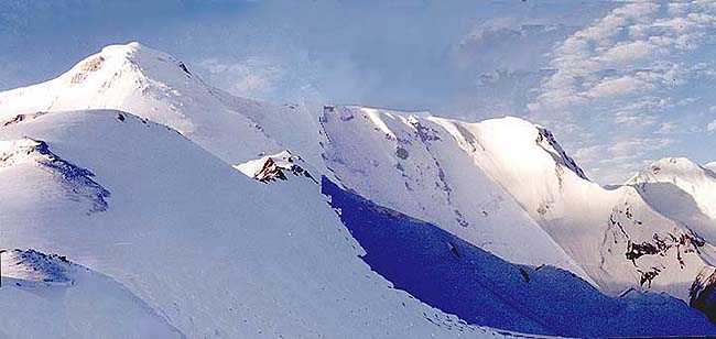
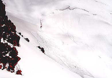
29.07-30.07 "Chetyrekh Mandarinov (Four tangerines)" pass (2B, 4700) The pass of "Four tangerines” connects the right inflow of Nura originating in the southern cirque of peak Belyi (White) and east extremity of Nura glacier. Ascending the pass begins on a valley of right inflow of Nura. In the bottom part of the valley on the left bank there is a clip which is bypassed on the upper grassy terraces. Further on all extent of the valley you have to go on near the water. The pass is situated in a long western spur of 4830 peak. The pass's slope has difference about 400 m, in the western part - danger of ice collapses. At smaller amount of snow than we had in this campaign the technical complexity of ascending the pass can increase, however physically the passage becomes obviously easier. Descent from the pass - short and rather flat talus slope. 31.07-02.08 Traverse of 4812 peak (2B) and attempts to ascend Erkeshtam. Generally speaking, we planned traverse of 4812 peak as a preparatory stage to ascent on Erkeshtam peak. Unfortunately, the ascent was broke because of the very bad weather, instead of it we had one and half a day forced rest. Therefore the traverse looked, perhaps not quite logical, but it was one of the most beautiful places for the whole campaign. Photo: A view from Velikiy Put (The Great Way) pass on Erkeshtam Peak Photo: Avalanche collapse under Erkeshtam Peak
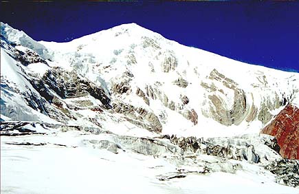
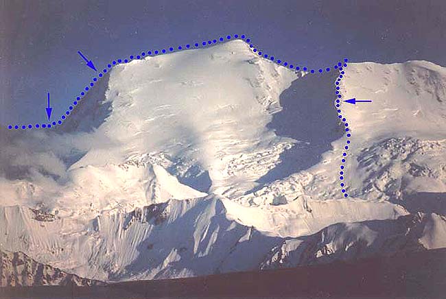
Traverse of Zarya Vostoka peak (6349m), 3B Traverse of Zarya Vostoka was undoubtedly a key element of our campaign. Zarya Vostoka - the second on the importance and the third on the altitude (after Kurumdy and 6384 peaks) summit of East Zaalai. We had planed the traverse having only a unique photo, and on it the route was not looked through suitable ridges for ascent on the main massif from Nura glacier. The descent ridge on East Kyzylsy glacier had been seen perfectly, therefore we had planned the route in two variants: one of them provided ascent instead of traverse the top of the pass in the northern spur of Zarya Vostoka. There are following variants of trip for the summit ridge.
1) Via the ridge of 5985 peak. This way, perhaps, is the safest. The ridge has distinct outline with a lot of places for spending the night. The main lack is unjustified length and deducing of the altitude at descending from the top on a saddle in the western shoulder. 2) Through a saddle in the western shoulder of 5985 peak. While ascending the saddle you should be afraid of avalanches and ice collapses from the southern ridge of 5985 peak. In the rest, the way is safe enough. On inclined snow fields before the saddle it is guaranteed deep breaking trail.
3) Through a saddle to the west of 5995 peak (we chose this way). Certainly, it is the shortest and economic way. A danger of moving snow slabs from the pass's slope is rather real. But under the slope there was no the slightest trace of avalanches, it and lulled our vigilance. The crux of this route is ascending the summit ridge with three abrupt sites with cornices. We climbed them beleying. The “Nochnoi Dozor (Night patrol)”pass on which we ascended from the north, can serve for passage of a ring around “Zarya Vostoka”. Thus it would appear a complex and interesting pass in a southern spur of the top to climb. 03.08. (13th day) At 8.30 we left our wonderful grassy sites to make way up to the summit first via the moraine on the left branch of Nura glacier. The glacier first consists of constant rises and descents on and from moraine crests. Then we went easily, the glacier is practically equal further and covered in carpet of fine yellow - grey stones. Having had dinner under the big stone we continued the ascent. The bright sun was shining, but it was windy. We could clear see the Zarya Vostoka summit. Then there appeared open sites on the glacier. We moved near to the right edge, bypassing a site of broken ice on the right, closer to the center of the glacier. From that place we had to rope up as closed crevasses appeared. We decided to spend the night at the top step of the glacier above a moraine ledge. We climbed the ledge on the left side of the moraine, and went on a snow slope in the top part. The moraine ledge is combined from large stones; there was not any the equal place for tent there. We set a camp on a snow near the stones. It was clear evening and we discussed the opportunity of traverse. The convenient for following ascent ridge had remained hardly below on the glacier. 04.08. (14th day) We left the camp at 8.30. We should descend little bit on the right board of a glacier to reach the convenient ridge moving to the right under the slope. Then we got to the basis of the ridge via the glacier, torn in places. We put on crampons and began making hairpin-bend ascent from there on snow, and basically, rigid firn, sometimes falling on 20 - 30sm. The steepness of the slope is about 30 degrees. By 13.00 we approached to the big bergschrund, here in the shadow of it we had dinner. The weather was clear, the sun was brightly shining and it was very hot. We left further from under a bergschrund at 15.00, bypassing from the left the big crevasse over the snow bridge. The snow became limp under the sun. We fell down knee-deep. Above we noticed the excess of the slope with ice dumps forming a platform. Obviously, it was a convenient place for spending the night. We went directly upwards, by 17.30 we approached under the dumps. Accurately we climbed this site on a break between ice blocks and we got upward, on the ledge. At 18.00 we settled a camp. In the evening it began snowing, but it covered in fresh snow only the ridge and our camp: it was clearly and sunny above all Alaiskaya valley. 05.08. (15th day) In clear morning at 8.30 we left the camp and for one trip we mounted on the bend of the slope. We could see the whole panorama of all summits in the upper part of cirque, opened in front of us. From the right Zarya Vostoka and from the left 5985 peak closes the cirque. Directly above us 5995 peak towers with great ice overhanging. On the right and to the left of the top there are lowerings of the passes. Our way lays on the right, near to Zarya Vostoka’s saddle from which the summit ridge begins. We went under the pass. Under the top of 5995 peak there are big cones of avalanches and ice collapses, we passed this place quickly and finally approached the col-raising slope. All the time we had hardly to brake trail, knee-deep and above. The col-raising slope is wide, with hanging cornices in its right part and ice dumps and crevasse on the slope. We began to ascend via its left part. There is a small bergschrund in the bottom third of the slope, we rather quickly mounted up to it and stayed to have dinner there. Then we put on crampons. From the bergschrund the steepness of a slope increases up to 40 - 45 degrees, the snow became rather rigid, but our movement was unreliable. We began fixing the rope using the ice axe. We made 9 pitches and found out that on the two last ones the snow was bad (a snow slab with emptiness under it). It was obviously avalanche dangerous. Two pitches more we traversed to the right and a little downwards and then got to the ridge. From there we went little bit on the ridge up to a convenient saddle. It was already 20.00 and darkness was coming quickly. In China was already absolutely dark. In the east we could see surprising vivid colours of palette. We named this pass as “Nochnoy dozor (Night patrol)” on association with well-known picture of Rembrandt. We settled a camp. It was blowing a very strong wind on the saddle, and even a rock under which there was set the tent could not protect against it. 06.08. (16th day) It was clear in the morning, we could perfectly see the entire ridge up to the top. We packed in the tent - the very strong wind continued blowing. We left to ascend further at 9.00. It became clear, that at such wind it was impossible to move, the wind simply put on the slope and we could get frost bitten. A little further on the ridge we put the tent in a small snow hole where the wind was hardly weaker. By 12.00 the wind abated, we quickly gathered and left again. Having descended hardly lower we saw clouds in all valleys: they were quickly rising. Soon visibility disappeared completely. It was snowing. It was impossible to move further; we had to set a camp. Till the evening the weather did not improve. 07.08. (17th day) In the morning there was low overcast in valleys. Clouds, as well as yesterday, were quickly rising. We mounted along the ridge (bad visibility: it hardly could be seen in two meters). Hoping for the best, we continued to move. At 13.00 we reached the turn of the ridge. Without visibility it was too dangerous to ascend further, from below we saw huge cornices in the summit part of the ridge. We dug out a small platform under our tent in 30 - degrees slope at the altitude about 6100m. Because of a lot of snow it could be possible to make an equal platform, despite of steepness of the slope. It was the rather critical moment - we had food remained only for one day more and tomorrow we would have to finish the traverse and begin to descend.
08.08. (18th day) We left at 8.00 without proper breakfast: only tea. Visibility was still bad; however, it was possible to move through knee-deep and more snow. For 1,5 hours we climbed three huge snow cogs: we saw them from below early. Then the ridge led us on the top of spanked ice block. It was already the summit plateau. We had a rest. The clouds for a while dispersed, in gleams far below all Alaiskaya valley was visible. It was a surprising view. In 20 minutes we reached the top. Clouds tightened everything around. The top of Zarya Vostoka represents a snow dome. Finally, we did that! One more time we looked at China side, Kurumdy, Alaiskaya valley and began descending on a ridge of the main range to the West almost at once put on crampons. For 20 minutes we descended up to a convenient place in a hollow for setting the tent. There are rocky sites on the ridge, under them the snow dome goes from the ridge. It began dense snowing. We left after a dinner at 15.00. A visibility was still bad. Quickly we descended almost up to the saddle in the ridge. Our descending ridge was somewhere upper the saddle. As we could see nothing, we waited for the while on our backpacks. At about 16.30 suddenly a miracle happened and clouds missed. From a saddle we ascended up to junction of ridges (it took about 20 minutes). We left on the descending ridge, having cut through a cornice and accurately belaying each other. Because of the bad visibility again having descended about 500 meters on the altitude, we chose a safe place for a camp. Here the ridge hardly turns, above turn of a rock so it was the right place with minimum of avalanche danger. We dug out a platform under the tent in 30-degrees slope. As we had trained a lot, it was already easily to do. The thunder-storm began with a strong blizzard, and the discharges sputtered on our hair. Finally we settled the camp at 19.00.
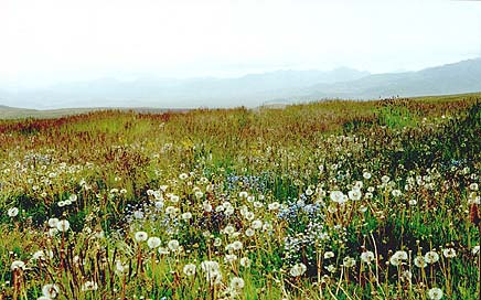
Next morning we traversed quickly from rocks to the left and we descended right by falling water line, bypassing seracs. The situation was dangerous very much: in several places snow slabs moved right under legs. Up to the bottom part of the slope we deduced 600 meters and went out very precisely - between ice dumps from the right and from the left. There are huge cones lying under the slope. Then we made our trip from under the slope to the left in a direction to the ice falls, which we had seen from above. We had a rest at the edge of the ice falls and descended it getting down and to the right, moving right under the ice walls. At the left, at the edge of talus edges, the ice also was also torn. We had to put on crampons to make 2 minute-descent on the flat glacier. At last, we descended! The mountain let us go away. We had a bite, and at about 12.00 we moves further on the open glacier, having roped up. Just from the ridge we noticed a beautiful lake below, on a high lateral terrace in a right pocket of the moraine at merge of branches of the glacier. The way on the glacier up to the lake took us one hour, and at last, we appeared in a paradise - green grass, flowers. The surprising oasis - in fact the moraine lays directly on ice. Quickly we had to take the full carry: a strong rain began and by the evening it passed in dense snow. However, it did not sadden a pleasure from the "king" dinner and supper. 10.08-13.08 Pass “Four ice falls” (3A, 5500m), Alexander Zotova's pass (3B, 6015m) Alexander Zotova's pass is located in the main range between TurkVo peak (6243m) and Chorku peak (6283m). The ascent goes on the implicitly expressed snow ridge from the plateau type saddle of pass “Four Ice Falls”. During the ascent you have break trail hard almost everywhere and fix 200-m of rope on an unreliable snow slope getting to the pass's ridge. If to make through passage of the pass it will be possible to expect not very complex ice fall on descent route. As it follows from the name that we gave to this pass during the ascent you have to climb four ice falls. First of them is passed getting to the right, and sometimes you have to climb on rather short (10 - 15 meters) slopes of a steepness about 70 degrees. The second ice falls is more expedient to bypass via the ice "tie" (350 meters of fixed rope) and the third and fourth ice falls have only "decorative" value and are easily climbed. All crevasses are covered in deep snow. The route of descent from the pass goes on a long and abrupt snow-ice slope.
14.08 Peak Chorku (6283m) Peak Chorku (on Tadzhik it means "Four sides") towers with a rocky pyramid above the main range approximately with 300 meters-height. It does not represent any complexities to summit it from Alexander Zotov's pass and the ascent takes about one hour. The summit tower of the pass is very beautiful, there is a remarkable view on Russian and Chinese Pamir, on the Karakul lake and East Pamir uplands from there.
15.08 Markansu Pass (3Ŕ, 5800m) Peak Markansu is a unique mountain, a route on which presents in the description guide of the area (the ascent of 1932). The pass Markansu is located in the Southern spur of peak TurkVo, between peaks TurkVo and Markansu (6010m). The pass is snow-ice, the western slope is rather long and abrupt and ascent on it also demands fixing the rope. From the pass it is easily to summit Markansu peak and peak TurkVo. It was interesting to us to pass through a plateau of southern inflows of Kurumdy glacier and to see the beginnings of the ice falls, going on Kurumdy glacier.
16.08 Traverse of 5917 peak (3Ŕ) Traverse of 5917 peak was planned as enough serious obstacle, however actually it appeared, that it does not represent any technical complexity. We had some difficulties at descent to the main ridge of Left Kichkesu glacier via a long and abrupt snow-ice slope.
We did not name the pass and the summit as in this case we were not trailblazers: some minutes prior to us leaders of German group summited the top from the West face. 17.08-18.08 Descent to Sarytash and further returning to Osh. The end of the campaign.
|
| © 1999-2007 Mountain.RU Mail to: info@mountain.ru |
|