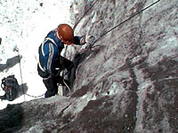
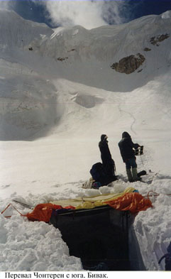
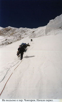
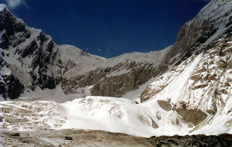
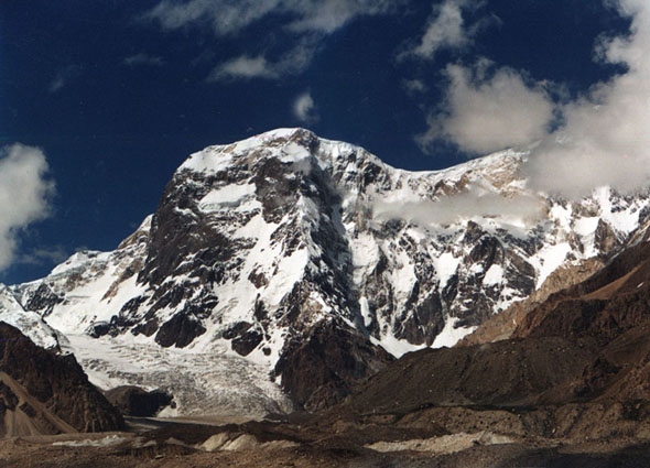
Chonteren Col 3B, 5488m
|
|
 |
|
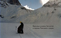
Chonteren Col
from the South and from the North.
|
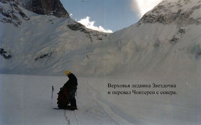
It is located in a Kokshaaltau ridge between
Pobeda East Peak and Peak of Military topographers, 3B.
It connects from the north –Little Star (Asterisk)
Glacier (South Inylchek Glacier), and from the south- Chonteren glacier
(Chon-Tereksu River).
It has done for the first time from the south
to the north.
The description is given from the Base Camp
on Chonteren glacier to the left side of the South Inylchek. The Col
radial climbed earlier from the Little Star Glacier during various
traverses and ascents on Pobeda East Peak and Peak of Military topographers
etc.
Ascent. Part1.
We moved from the Base Camp to the Glacier,
crossed it towards the right-bank pocket and climbed it on scree.
Then we passed the pocket overgrown with grass to the rocks in the
end of the pocket and descended along the rocks on conglomerate to
the glacier. We found out that in that place the glacier had an upgrade
slope like a steep step (30-40m) with continuously collapsing stones.
We had to go round that place climbing 40m via the rocks on fixed
ropes. Further we went along the right-side of bergschrund (conglomerate
and big stones) and ascended to the right inflow of the glacier. Right
away we climbed on scree to the right-bank pocket with a lake, where
we found our food we had put by in the beginning of our expedition.
We passed the pocket up to the end and descended to the glacier. Having
crossed a big right inflow streaming to Chonteren glacier with 5 quite
big brooks (the distance between them was about 300-400m, we forded
them on stones). Then we again ascended into the right-bank grassy
pocket leaded us practical to the upper reaches of the glacier. From
there we again descended to the glacier along the rocks on scree and
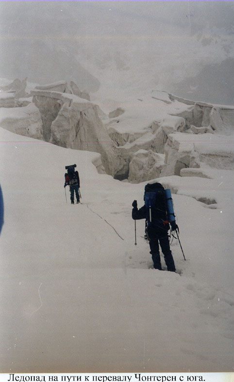
conglomerate and moving on open and plane ice we approached the ice-fall.
At the same time there was a grandiose collapse from the ice-zone
of Pobeda East Peak. It was better to go round the bottom part of
the ice-fall on the scree from the left side of rocky rigel propping
up the ice-fall. There was a good place to settle the camp on it.
This entire ascent took us 10 hours 10 min.
|
|
|
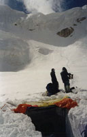
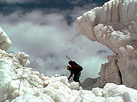
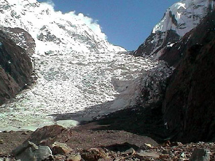
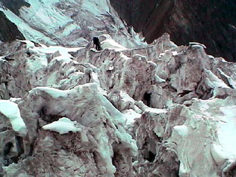
The ice-fall
on the route to Chonteren Col from the South.
|
Part 2.
The ice-fall was strongly blown up with huge
ńrevasses. There were the bridges over them on the whole from the
right side under the slopes of Pobeda Peak. Practically everywhere
on the ice-fall we could see the signs of the ice collapses from Pobeda
East and in places - from Peak of Military topographers. There were
not many safe sites there. We have to move along the right site trying
as far as possible to keep away from the slopes. There was snowing
and confined visibility. Sometimes we couldn’t see the relief and
folds of the glacier. We spent a night in a safe site between great
ńrevasses. In the morning we had to move hard again hacking through
the snow. Soon we went on a flat closed glacier re-covered in its
most part with ice blocks collapsed from Pobeda East. We tried to
keep to the left and towards noon we settled the camp near the place
when the col-raising slope began. 8 hours 55 min.
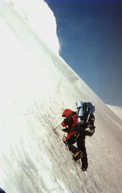
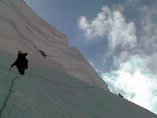
Ńol-raising slope – a snow-ice slope
in extent of 600-800m, with an average steepness of 40-65 degrees.
There is a huge cornice (10-60 m or possibly 100m) in the upper part.
The steepness there reaches 60 degrees in places.
|

|
|
|
|
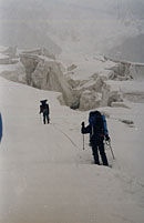
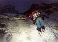
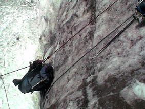
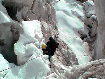
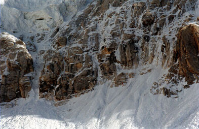
The fragments of the
ascent on Chonteren Col, 3B.
|
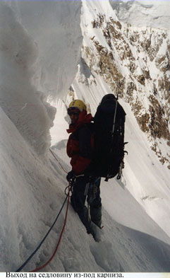
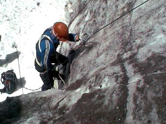
Part 3. There are a lot of places to
start ascending but the most preferable variant is the going out in
the right part of the cornice as bit upper then the saddle. We went
early in the morning on an avalanche situation slope towards the ice
brow sticking out of the snow. The snow was dangerously crunching
under our feet. So we had to reach ice and then to fix the rope in
spite of the small gradient (up to 40 degrees). We made two pitches
to reach the ice-wall, from which there was an output to the ice part
of the raising slope. Further we made two pitches more upper on ice
(45-60º), one pitch to traverse to the right and upper and the
last one upper under the cornice. Then we climbed one pitch along
the cornice to the right and went out on the ridge. Having descended
up to the waist through the snow roped up for about 20 min we got
to the saddle (It was very steep slope 50-55º, 8m, on three times).
9 hours 15 min.
The saddle- a wide snow ridge with cornices
hanging to the south. You can set a camp and spend a night practically
in any place there.
Descent. Part 1. A steep (till 55º)
snow 200m-slope cut by rantcluft extends to the North. Below the rantcluft
there was a long snow slope with bergschrunds and not great ice-falls.
We went roped up and to fix the rope to get over the rantcluft. The
belayer just jumped over it without a rucksack. Then we took the way
moving mainly up to the waist through the snow to the right to go
round the bergschrunds and ice-falls. On avalanche cones we went out
to the Zvyozdockka (Asterisk) glacier. 2 hours.
Part 2. We went on the closed Zvyozdockka
(Asterisk) glacier. The ice-fall was gone round along Lavinny (Avalanche)
Col on the trail well viewed from a lot of points and hacked by Novosiberians
and marked by signal flags. Under Dikiy (Wild) Col we went on the
beaten trail to Pobeda, moved along it not roped up over the bottom
ice-fall and on the open glacier we went out on the right-side moraine
(marked trail) and settle the bivouac in suitable place. 6 hours.
The General time of passage- 36 hours 20 min.
(Five days)
Time of ascent - 28 hours 20 min.
Time of descent - 8 hours 00 min.
Time of movement with belay- 24 hours 10 min.
Points of belay- (snow, ice)- 3/20.
Valery Khrischatiy Col 3B, 3B, 5300m, first
ascent
|
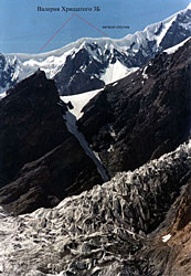
the Valery Khrischatiy Col, 3B, a view
from the Tugbelchi Glacier, from the East. Descent.
|
It is located in Meridional rande between Toreza
6401 Peak and Druzhba Peak.
It connects from the East Tugbelchi Glacier,
China and Druzhba (Southern Inylchek) Glacier.
It’s first ascended. The team leaded by Valery
Khrischatiy climbed it earlier when they were traversing Pobeda Peak-
Peak Khan-Tengri. We have called it as Valery Khrischatiy Col in memory
of the great climber Valery Khrischatiy who perished in huge ice blocks
collapsed from Chapaev Peak on Semyonovsky Glacier.
The description is given from our last camp
to the right-side moraine of Tugbelchi Glacier (China).
Ascent. Part 1. First we went on a marked
trail along the left side of Southern Inylchek Glacier, then on closed
Southern Inylchek, Druzhba glacier. There were a lot but quite predictable
crevasses. So we fell in them sometimes. 8 hours 25 min.
Ńol-raising slope - a snow-ice slope 250-300m
in length, with an average steepness of 30-45 degrees and with a sequence
of not great ice-falls and bergschrunds and an ice cornice.
Part 2.
Having passed the bergschrund we fixed the rope,
climbed one pitch and moved further roped up on three times in places
until we reached the saddle. The category of difficulty of that part
of the route was about 2B. 1 hour 45 min.
The saddle – a quite wide (300-400m) snow field
come abruptly to the East with a huge cornice. We spent some hours
trying to find the acceptable route of descent.
Descent. Part 1.
|

Descending over the
cornice of Valery Khrischatiy Col, 3B.
|
The descent started a bit to the North from
the saddle, hardly further then typical bend of the ridge turning
there to the West.
We dug the cornice straight on the output to
an ice-rocky buttress going down to the East and turning into the
ridge lower. There are two routes from the ridge: to the left towards
the upper plateau and to the right in the ice couloir leading to the
bottom plateau. We descended on 4m- overhang site of the cornice making
a catapult with an ice axe. The last climber descended without a rucksack,
as the point there didn’t seem as a safe one. Then we fixed the rope
on an ice screw and moved through deep snow, reached the battress,
went on it on the ice along rocks, and then on the wide ice couloir
kept to the right and having made 8 pitches we reached the bottom
plateau. Then the slope was rather steep (40-45º), but the snow
was quite deep and the end of the slope seemed normal below. So we
went roped up reducing the altitude on 200-300m more till we reached
the bottom plateau. Then we found out about the route of further descent
and went on scree saddle straight on the East from the col-raising
slope (closed glacier,
on the ropes). There was a cairn on the saddle.
Further we went on a snow-ice-strewing couloir (30-45º, 500-600m)
made 7 pitches in its upper part. Then we went to the left on a rocky
scree and conglomerate slope on which we descended to the rantcluft.
The cracks we passed over the cones in the bottom part of the couloir.
5 hours.
|
|
|
|
Going out
of the rantcluft during the descent from Valery Khrischatiy
Col. Pulling out our rucksacks.
|
Part 2. Descending through the rantcluft.
The descent straight down is possible but too dangerous as it leads
to the ice-falls of the col’s bottom plateau. Therefore we began to
climb on the glacier in the bottom part of the ice-fall from the upper
plateau. We climbed the site with an overhang bottom part (4m) and
a vertical upper part, then a 40º-site (20m) and the last site
(25-30m) to the right towards a plane glacier. We had to transport
our rucksacks separately first 20 meters. 4 hours 55 min.
Part 3. We went on an ice-fall, then on an open
strongly torn glacier. Little by little the crevasses forced us out
to the right side rantcluft. We descended on it to the right side
moraine. We had to move in crampons on front points on three times.
1 hour.
The General time of passage- 20 hours 55 min.
(Three days)
Time of ascent - 10 hours 10 min.
Time of descent - 10 hours 45 min.
Time of movement with belay- 17 hours 25 min.
Points of belay- (snow, ice)- no less then 4/19.
Tugbelchi Col, 3B, 5200m, first ascent
|

|
|
|
Tugbelchi
Col, 3B, from the North and from the South.
|
It is located in the East extension of Kokshaaltau
ridge, to the west from 6435 Peak.
It connects from the North Tugbelchi Glacier,
from the South Kichikteren Glacier (Kichik-Tereksy river).
It’s first ascended from the North to the South.
The description is given from the right lateral moraine of Tugbelchi
Glacier to the Kichikteren Glacier snout.
Ascent. Part 1. The approach to the ice-fall
first on the moraine and then on the open ice of the right inflow’
left bank of Tugbelchi Glacier took us 45 min.
Part 2. The ice-fall in the extent of
about 4 kilometers. The steepness of the bottom site (1 km) is about
30º, and upper- 5º. It’s strongly torn on the all extent.
There are a lot of huge seracs in height up to 100 meters and more.
To pass this site is required not less than two days. The bottom part
is passed on the center. We had to climb a lot of sites (in extent
of 2-4m) on front points. Having passed the flattening we had to begin
to move to the right-bank rantcluft. It appeared much more difficult
than to pass the first site. We had to pass over the open-work bridges
between the seracs, fix the rope up and down and the entire time move
on first points. We bypassed the pat of the ice-fall through the rantcluft
till we reached the small glacial circus with overhanging ice-falls
with something regularly falling off from them. From that point we
had to come into the main already quieter ice-fall with extended hollows
between seracs. And soon we changed our crampons to snowshoes. There
were less steep sites then in the beginning. The route of movement
ran closer to the center of the glacier, and in the top part the breaks
superseded to the left board. The movement on the glacier took us
19 hours. Further the flat glacier was cut up by the big cracks. We
had to wind between the cracks, gradually being again displaced to
the right board towards the saddle. Moving on the deep snow along
the right-bank we approached under the col-raising slope. 23 hours
20 min.
|
|
|
|
|
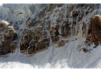
The fragments
of ascending on Tugbelchi Glacier
|
Part 3. The Ńol-raising slope
is a snow-ice slope in extent of 350-400m and with 20-30º- steepness.
In the bottom part there was a big edge which we had to bypass to
the right. Further we went the slope part with some steps raising
to the cornice. We reached the right part of the cornice. Its main
part overhangs directly from the saddle. We fixed the rope (20m) and
over a small snow-ice bergschrund (50º) and a little cornice
(50cm) we dug we went on the saddle. 40 min.
The Saddle- is a crest with the cornices hanging
to the north. It is possible to spend the night there but there is
no sense to do that as up to an equal plateau on the southern side
it’s less than 20m.
Descent. Part 1. The snow-ice slope (20m,
10-20º), then the flat plateau, breaking downwards a hanging
glacier and a rocky wall of the common height of 300-500m. We went
the plateau roped up and then we had to spend three hours to reconnoiter
the acceptable route of descent- on border of ice and rocks to the
left of the hanging glacier. We crossed the plateau to the left downwards
and reached the entrance of the couloir. 2 hours 30 min.
|
|
 |
|
The fragments
of descending on the Southern Wall of Tugbelchi Col
|
Part 2. The Wall in this part is about
300 m in height, an average steepness about 70 degrees, the minimal
steepness – 60 degrees, there were also ledges with the steepness
of 50 degrees and some meters in extent. The first pitch was on ice
couloir between ice and rocks; the second pitch was first on ice through
the narrow steep bottleneck (8 meters). Then we had to leave on the
rocks avoiding possible collapses. Avalanches started to descend on
the couloir. Further we descended meters 30 to the left downward on
ice and came to the rocks. We made 5 pitches descending to the bottom
cones. During a moment the one of avalanches carried away one our
backpack with a tent, gas, a torch, etc. Not descending two pitches
more up to the bottom we settled the bivouac. 11 hours.
Part 3. The snow slope (300-400m) all
in avalanche cones. The steepness in its upper part is about 45 degrees,
lower it is flattering and passes to the plateau of the glacier. On
the cones we descended to the plateau and pick up the gear from the
backpack we lost. Further we move roped up first on the center and
then to the left toward the rantcluft bypassing the small ice-fall
and on avalanche cones we descended to the left lateral moraine. 1
hours 30 min.
Part 4. Moraines and open ice of Kichikteren
Glacier. We went on the moraines to the plane part of the glacier
and passed it till the covered part of the glacier, then we went on
the left side and descended along it to the glacier snout whenever
possible rising upwards, into the grassy pockets.
The General time of passage- 47 hours 45 min.
(Six days)
Time of ascent - 24 hours 45 min.
Time of descent - 23 hours 00 min.
Time of movement with belay- 38 hours 10 min.
Points of belay- (snow, ice, rock)- 10/10/7.
The analysis
of the route, conclusions, recommendations
The route we gone opens new area for new expeditions,
basically, for the campaigns of 6-th category of difficulty and represents
boundless opportunities for passage of new cols. According to the
map the sizes of Chinese part of Tien Shan is treble the high-altitude
Kirghiz part. We only have reconnoitered the area, trying to connect
plenty of cols of the well-known Kirghiz part of area with Chinese
one. There are four such cols now - Chonteren (3B, 5488m), Valery
Khrischatiy Col (3B, 3B, 5300m), Inylchek (2B up to the plateau of
Tugbelchi Glacier, 5500m) and Przhavalsky (3B, up to the plateau Tugbelchi
Glacier, 5800m). The last two ones still wait for pioneers to climb
the ice-fall of Tugbelchi Glacier, which we overlooked in our expedition.
There is still absolutely untouched a huge area of Temirsu glacier
with a possible exit to Kuyukap glacier, and set of other adjoining
glaciers. Also the east part of area where the passage of cols between
Kichikteren and Tugbelchi glaciers is possible stays still unexplored.
If have a look farther on the east and on the north there stand out
tens not gone cols and tops higher then 6000 m. Nevertheless, the
good beginning is set. A good beginning is a half the battle. The
expected complexity of the not gone passes is 3Ŕ-3B, but I think,
that you can find even some simpler cols. We have reconnoitered the
one such col - from Chonteren glacier on Kichikteren glacier. It can
become a good starting col through which it is possible to throw food.
The simple col is seemed also from Sailyksu glacier to the settlement
Talak, but we had time to reconnoiter only the exit to Sailyksu glacier.
The analysis of area of the expedition.
First of all, the area amazes imagination. I do not know the reason,
probably, it is connected with more southern arrangement, and, accordingly,
with stronger thawing of the glaciers, but mountains here are appreciable
more abruptly, than in the next area of ridges Tengritag, Sarydzaz
etc. As the result, - there are not simple cols there. All cols have
bilaterial character, their northern slopes are mostly ice, sometimes
with exits of rocks, but southern ones are rocky talus, or also snow-ice.
On the south frequently there are steep dumps. Practically all cols
"are supplied" with cornice. The average steepness of col-raising
slopes is approximately 45 degrees. Practically there are a lot of
ice-falls on all inflows of large glaciers, which look very much exiting.
As a result of the analysis of the area I should tell the following:
while for today the area is cleanly 6th category of difficulty, and
simpler campaign is not possible here.
The area climate is obviously drier i.e. Kokshaaltau
ridge appears as the barrier. Grassy pockets meet practically up to
bottom of the ridge. There is more naked ice, and the ice-falls are
more torn. But because simply huge quantity of snow this year and
conditions of this season on Chonteren glacier it is felt less. And
if to go farther to the east the dryness is even more expressed. Tugbelchi
Glacier in this sense is most indicative - it practically from its
upper parts has the forms similar to Southern Inylchek glacier in
the bottom flow. The ice-falls come to end - and hills, and, likely,
the rivers begin. And when we sat in an obvious cyclone during the
ascent on Tugbelchi Col, the snow here did not go, and simply "exuded"
from a cloud within three days, only for the fourth day it was a bit
heavier snowing. I think, for same time on the other side of the meridional
ridge there was on some orders heavier fall of snow that time. Sometime,
I hope, I shall get here once again to continue the development of
this glacier too.
Cols. First about that cols we have passed.
The col we named the “Ladybird” received that name because
of the glacier to which its southern slopes lay down was entirely
covered with ladybirds. The col has two saddles: east and western.
The east one is ice-rocky from the north. There is a direct descent
to Ladybird glacier from it on the rocky-snow-talus couloir and then
the small ice-fall. The descent from the western saddle to the south
is problematic, but the ascent from the north is a little bit easier,
but from the saddle there is a direct way on the ridge to Plateau
Col. East saddle was not visited by us. A narrow snow-ice ridge with
cornices and rocks sites connects the saddles. To pass it needs to
use the special equipment. The east saddle may be considered as independent,
and the western one - as a fragment of the ascent on Plateau Col.
The set of obstacles on a radial going out on the col determining
its complexity are: the ice-fall, flat, but labour-consuming, to pass
it needs about one day; the col-raising slope - an ice slope of 45-60
degrees - in extent not long, but very abrupt, as a result we estimated
it as 3Ŕ. Time of passage of the mentioned sites - not less than 2
days (we went 3 days).
Plateau col received this name according
its destination. It is intended for an exit on the top plateau of
the Ladybird glacier to go around of the 1,5-kilometer ice-fall for
the following passage of the col on Temirsu Glacier and for the crossing
to the middle plateau of the Ladybird glacier (to by-pass the bottom
part (600-meter) of the ice-fall) and for the following passage of
the Cosy Col. It doesn't have the independent value. The Col is sated
with a various snow-ice relief. The key sites determining its complexity
- 3B - are: a sharp snow crest with cornices - very original technical
site; an extended snow-ice crest with cracks, bergschrund, ice dumps;
an ice-fall with difference of altitudes about 1 km. To pass it from
the saddle of the Ladybird Col is required not less than 2 days, but
likely, even 3 days. We, in view of the bad weather, went more than
3 days. It demands for 4-5 days to traverse Plateau col and the Ladybird
Col together.
Cosy Col. Giving the names to the inflows
of Chonteren, we tried to repeat the same names and in the cols names.
The Complexity without the passage of the bottom step of the ice-fall
of the Ladybird glacier is 3Ŕ, with passing that ice-fall it can turn
out 3B. The Sites determining the complexity are: from the north -
an ice slope up to 60 degrees, 200 m; from the south - rocky-strewing
slopes with snow and ice sites above a 300-meter rocky dump. Directly
the col-raising slopes are passed for a day. To pass the ice-fall
takes one day. The complexity is good and interesting 3Ŕ route.
Chonteren Col has that name already for
a long time. It was visited earlier from the north during different
ascents and traverses of the adjoining tops. We have made the first
passage directly through it. The sites determining the complexity
are: an ice-fall during the ascent; an ice-snow-raising slope with
a huge cornice on the top, the northern col-snow-ice slope with the
rantcluft, ice dumps, bergschrunds. For passage from the bottom of
the ice-fall up to upper parts of Asterisk glacier is required not
less than 3 days (we went 4).
Valery Khrischatiy Col as also the Chonteren
col, connects two worlds - Kirghizia and China. The desire to pass
it ripened in me since 1993 when we passed Vysoky (High) Col. And
the name - in this area I wanted to pass Valery Col - especially,
on this saddle he was, making the traverse of Pobeda Peak - Khan Tengri
Peak in 1990. The Col is snow-ice, with huge cornices on both sides.
The sites determining the complexity are: the western slope with bergschrund
and cornices (at a level 2B), the passage of the cornice to the east
(digging through it, overhang part of 4 meters), an ice-rocky buttress
and then the ice couloir of 800-900 meters (9 pitches in the top part,
a steepness up to 55 degrees), the second ice-rocky couloir in the
extent of 700-800 m (7 pitches in the top part, a steepness up to
50-55 degrees), the passage of rantkluft (ice, overhang in the bottom
part, separate transportation of backpacks). Except for a set of technical
obstacles the col is complex in the tactical plan too.
Tugbelchi Col 3B. This col can be named the
big puncture. No, not because we were not ready to go it, and not
because the route appeared the most complex than we expected. Simply
we had some materials about the cols: a topographical map with opportunities
already described earlier, and pictures from space somewhere of 70th
years. They gave representation even about the character of the col
slopes. We could see the ice-fall there. But it was not real to understand
its complexity on those pictures. A steep wall was not visible at
all. And on the map descent to the south from the col seemed not more
abruptly then 20-25 degrees. Therefore complexity of the col we expected
2Ŕ-2B, a maximum 3Ŕ. But already the ice-fall gave complexity more
likely 3B. And we did not also expect to descend on a wall at all.
We planned 2 days for this pass accordingly but it took us 6 days,
one day of them we stayed sitting in a bad weather. Taking into account
starting delay to pass the last col seemed simply unreal. But it was
not so bad, as a result passed on one more valley and found out the
road about which we knew nothing. So, the sites determining the complexity
are: the ice-fall (2 days), a wall on descent with an average steepness
of 60-65 degrees, the sites up to 80 degrees, 300-400 m.
Other cols. We are preparing for the
review of all possible saddles, the tentative estimation of them we
have made (David Lehtman is engaged in that). I hope, the review will
help to organize new expeditions to that area.
Conclusions, recommendations: the area
is perspective, but in the near future there is meaningful to make
campaigns only of the sixth category. If to pass 10-15 new cols it
will be possible to male more simple campaigns. The area is heavy;
therefore only the groups with the participants having already corresponding
experience in high-altitude climbing desirable and in passage of complex
cols should be allowed to start the routes there. There have not been
found simple cols in that area yet. Under my assumptions the further
research will lead to occurrence of several cols of 2Ŕ-2B, and a plenty
cols of 3Ŕ-3B. There are many still unclimbed tops with the altitude
above 6000m there, and different radial going out and traverses are
possible. If to begin routes from China it is better to arrive in
Urumchi, then to go by train in Aksu, and farther to go to the mountains.
Arrival - departure
"Tien Shan Travel" firm kind offered us the
services. First we arrived in Bishkek. Then we reached Osh, and then
by car - Irkeshtam. Further we went by car again from the Chinese
board line to Kashgarand, Then by train to Aksu, and again by the
car 140 km up to settlement Talak. Further a caravan of 4 horses went
to Chonteren glacier. On the back way we got out from coal-mining
factory in Kichik-Teren valley by the car to Aksu and all upside-down.
A total cost of the expedition was about $1700-1800 from the person.


