|
|
|
|
|
 |
|
Mountain photos - amateur
and professional photos of mountains.
|
| Climb > |
|
Author:
Oleg Fomichev,
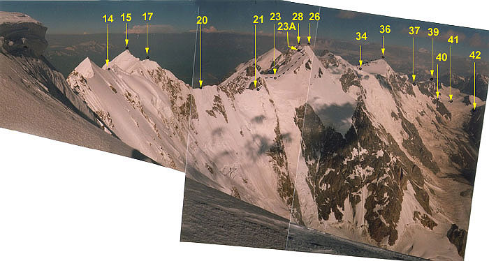
Route description Part 2 5th day (11.08.97) Packing his rucksack in the early morning Artem fell over on an equal place. Not fastened removable lid of his rucksack dropped out and unsuccessfully slowly slid off into a small hole in the bergschrund. It took us about one hour to get into the bergschrund through another hole on 25 meters and to search the lid. But we met with failure. It was a very pity that we lost the whole day time portion of sweet and an inedible but expensive portable radio set “Dragon 101 +”. After searches we understood once again that the bergschrund was a dangerous crevasse. After we dipped 25 meters it lasted more downwards on about 30 meters at least gradually narrowed. All the day long visibility was good. There was no snow or snow sleet, but the constant strong wind blew and due to it we put on all out warm things and did not take off our down parkas since the early morning till the evening. In general weather conditions were good. Site (14Ŕ) - (14) We got back on the Great Caucasus Range on a 100 m-snow-ice slope of 45 degrees via the fixed rope that we had left yesterday evening for 30 minutes. Site (14) - (15) On a flat southern slope of about 35 degrees near to a flat ridge climbing two gendarmes on short snow-ice abrupt sites we moved further with alternate leading about 100 m and the simo-climbing about 2 hours and 30 minutes up to the Shkhara Western summit. There we took a note of a team from Riga, Latvia, dated 01.09.1995 (4 climbers, the head - Pavlov Dmitry, traverse Bezengi Wall from the east to the West). Shkhara Western summit is the most difficult of approach.
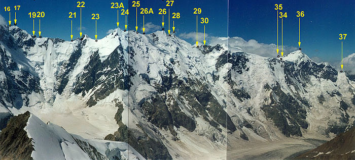
Site (16) - (17). Up to Western Dome via a snow-ice slope of 35-40 degrees to the left of the ridge of 120-150 m (simo-climbing and alternate leading). 30 minutes (upwards). Site (17) - (18). Up to the snow cofferdam under the 7th gendarme of Shkhara serrate (“Saw”, “Pila” (Rus)) on an abrupt rocky-ice ridge with several rocky gendarmes we climbed 100 m via fixed ropes (on rocky ledges and bolts) and climbed 100m (alternate leading). About 2 hours (downwards). Site (18) - (19). Up to the snow cofferdam between the 7th and 6th gendarmes first upwards 20m via fixed ropes on a snow slope of 35-45 degrees to the left of the ridge to the 7th gendarme, then traverse on a snow ridge of 25 degrees about 30 m and rappelling 40 m on rocks of the 3rd grade for an hour. Site (19) - (20). Up to the trough between the 6-th and 5-th gendarmes, bending around the 6-th gendarme from the right and then traverse on snow-ice slope of 40 degrees, 50 meters of fixed ropes for 30 minutes. Here in a convenient place we stopped to spend the night. 6th day (12.08.97) It was cloudy till the afternoon, but visibility was good and it wasn't snowing. Right then a snowstorm began. Site (20) - (21) 5-th, 4-th, 3-rd and 2-nd gendarmes of Shkhara's "Pila". We had expected to see something more terrible according the route description in Naumov's book. But it seemed we bypassed the rocky wall of the fifth category of complexity on more simple rocks. From the trough we ascended about 100 m on a simple snow-ice ridge (cornices!!) on the 5-th gendarme and then on a rocky slightly snow-covered ridge with dangerous cornices from the north. The rocks are simple and of average complexity, but a proper safe belay needed to be organized there. If we could identify the fourth gendarme but it was rather difficult to do that with the 3-rd and the 2-nd: they represented the ridge of high irregularity with several elevations and set of rocky fingers, towers and dips. We climbed that site alternate leading. Four times we had to rappel on 30 m, two times - on 7 meters and once on 40-50 meters. Prior to the beginning of a snowstorm we had time to pass up to a wide saddle between the first and second gendarmes for five hours. 7th day (13.08.97) At night and in the early morning there was a strong wind and it was snowing. From 9.00 till 11.00 the clouds were blown away for a short while. We enjoyed views of the blue sky and Dykh-Tau massif. Then clouds involved everything around again and in the evening it began snowing. Site (21) - (22) We ascended (alternate leading with chocks, friends, rocky ledges) the "first" big gendarme via a rocky ridge of the 3-rd grade (about 200 m), further traversed 50 m on a very torn ridge hardly from the left and rappelled 50 m on abrupt rocks of 3-rd - 4-th grade and reached a snow southern slope of 35 degrees located hardly lower than Sandro cofferdam (4800 m) between Mt. Shota Rustaveli summit (4960 m) and the first gendarme. In total we spent about two hours.
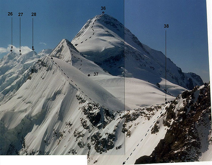
Site (23) - (24). From the saddle on a wide snow-ice slope of about 25-35 degrees we got to the north-east ridge (about 40 degrees) of Dzhangi East summit where had fixed the rope (about 50 m) on ice before the ridge. From there we moved further with compass reading as visibility was 200-300 m in rare seconds and we had to climb a wide long slope on a bearing. We climbed about 150 m on the slope of 20-30 degrees from the left of the northeast ridge up to Dzhangi East summit (there were dangerous cornices on the ridge!). From Dzhangi East summit 40 m of fixed rope and 40 downwards (simo-climbing) on a snow northern slope of 45-35 degrees near to the ridge up to a snow saddle. It was a good place where we managed to shelter ourselves from the wind. In total 1 hour and 20 minutes. We had time to go further, but because of absolutely bad visibility it was very dangerous to do. 8th day (14.08.97) We had to have forced rest because of constant blizzard. 9th day (15.08.97) At about 9 am when visibility improved up to 50-100 m and atmospheric pressure began to rise, we started to pack quickly hoping for the beginning of good steady weather. Site (24) - (25). As soon as we left the saddle to the West and began to climb the southern snow slope of 20 - 35 degrees following the ridge we understood that many our hopes appeared just illusion. A dense cloud involved the mountains again and visibility became no more than 20 m. But nevertheless we accurately crept about 250 m up to "Snezhny Kupol (Snow dome)" gendarme and after it we descended on a snow slope of 25 degrees about 50 m to a huge cosy crevasse from the gendarme's northern side of for 20 minutes. It appeared a very good shelter from the wind. And we became farther to sit there and dig out from snow. The blizzard ended in the evening. 10th day (16.08.97) In the morning till 10 am there was remarkable weather - slices of the dark blue sky were sometimes visible. But we did not see Dykh-Tau at all. But then clouds densely shrouded us again and soon a strong wind and snowing began. Site (25) - (26). Up to Dzhangi Main (5085m) we climbed from the left of the ridge on a flat wide, snow-ice slope of 45-50 degrees in places. 25 m, about 30 minutes. Site (26) - (27). Up to the saddle between of Dzhangi Main (5085m) and Dzhangi Western (5038m) summits on a flat wide ridge for 10 minutes. Site (27) - (28). Up to Dzhangi Western summit on a flat snow-ice ridge (with cornices!) and a short (25 m of fixed rope) heavy snow-covered rocky site (2-3 grade) before the summit, about 1 hour and 30 minutes. Site (28) - (29). Descending from Dzhangi Western summit on the western ridge abruptly leaving downwards we used the compass again. In a dense fog we went first on a southwest ridge, but then had to return. The southern ridge leaves from the summit too. Then we descended on a sharp snow-covered torn rocky ridge of 2-3 grade about 200 m downwards on fixed ropes. The rocks are strongly destroyed with "moving" big stony plates and blocks. All the cracks were densely filled with ice and snow and we could not use chocks and friend to organize proper belay and had to bolt. Then we climbed about 200 m with alternate leading on a snow-ice slope of 40 degrees hardly more to the left of the ridge (very dangerous cornices hanging to the north!). Then we went 100 m on a flat southern slope near to the ridge (simo-climbing) and 100 meters more m on a snow-ice slope of 40 degrees (alternate leading). Further 75 m again on heavily snow-covered rocky (2-3 grade) ridge on fixed ropes (bolts) and 100 m on a snow-ice slope of 40 degrees near to the ridge (alternate leading, ice axes, ice screws) . Then 150 meters more up to the Halde cofferdam before the rocky gendarme "Plosky (Flat)" on a flat snow slope to the left of the ridge (simo-climbing). We could not find any convenient place for tent from the saddle between Dzhangi Main and Dzhangi Western summits up to a saddle of "Plosky (Flat)" gendarme. It would be rather problematic to dig a platform or a cave at Halde cofferdam in snow-ice slope of 40 degrees because of that fact that the layer of snow with a layer of thin ice was about 30 cm, there was firm ice deeper. We had to descend from Dzhangi Western summit up to a place of spending the night in very severe condition: visibility varied from 3 up to 100 m (about 30 m on the average), a constant strong southern wind, sometimes with snow showers. A lot of time we spent clearing our way on strongly snow-covered destroyed rocks and on the organization belay (with ice screws) as we had to dig up to ice the "pie" of snow and ice only using an ice axe. From Dzhangi Western summit under Plosky gendarme we got for 7 hours. Site (29) - (29Ŕ). On Halde cofferdam we were looking for a place under our tent a lot of time. One time we noticed a bergschrund on a southern snow-ice slope about 45 degrees in 130 m lower than the cofferdam of Plosky gendarme. We descended to it on fixed rope for 40 mines on the left side of a wide snow-ice slope - couloir. On the right side there was a potential danger of rock falls from the gendarme. Having found a safe place in the bergschrund we stayed there to spend the night. The slope below gradually began to be more flat from 35 up to 20 degrees. And it is possible to dig out a place under a tent there too. In the evening this slope with rare crevasses looked through for about 1 km downwards. Then the quantity of crevasses increased, the glacier became narrower, and an icefall begins, where, probably, nobody has been before. 11 day (17.08.97) All the day long a very strong wind blew above the ridge. Till 10 am we could see the dark blue sky. Then again clouds appeared and we were not pleased with the visibility of about 20-30 m. Site (29Ŕ) - (30). A wide snow-ice couloir of about 45 degrees leaves to the west of rocks of the gendarme "Plosky (Flat)" to snow cofferdams of the ridge. More to the left of the cofferdams the ridge of Mt. Lakutsa and peak 4859 summits is allocated before its merge with The Great Caucasus Range. From the bergschrund we climbed 225 meters via fixed ropes on a snow-ice slope of 40-45 degrees near the rocks of the couloir's left side up to the second cofferdam more to the right of peak 4859. Further we traversed 25 meters on a snow-ice slope of 40 degrees, bypassing rocky sites from the left and heading on the cofferdam closer to peak 4859. On the ridge there was a very strong wind, a fog, visibility about 20 m. At the cofferdam there were two small snow-ice troughs where it was possible to set a bivy. We needed for some time to determine our location. In rare seconds of sky clearing we could notice gendarmes of the Mt. Katyn's "saw" and the ridge of Mt. Lakutsa. We were in a place of merge of this ridge and The Great Caucasus Range. In total we spent about two hours. In the trough before a rocky scarp to Bezengi glacier at about 4840 m we set a bivy to spend the night. 12 day (18.08.97) At night and all the next day long a very strong wind from the south blew over the ridge. In the morning the temperature in our tent was negative -4,7C. Without warm mittens hands just froze up on the wind in two ups, therefore nobody offered to go to gendarmes of the Katyn's "saw". All the same visibility was poor- about 25 m. We got in a very difficult situation: we had food and gas remained only for two days, and we were still far away up to our depot left on pass N. Tsanner. Site (30) - (31). In the morning we took a successful reco of an abrupt ice southern slope of 45-50 degrees that deduces from The Great Caucasus Range to Adish plateau. It began from the ridge in 4 meters from our tent. The scout descended 50 meters on fixed rope and had to wait for a "good" visibility for a long of time to find the further descent route. We had luck and found it without difficulty. We descended 350 meters more on abrupt ice slope of 45 degrees for a bergschrund on a flat plateau of Adish glacier between the ridge of Mt. Lakutsa and the southern ridge of Mt. Katyn (4974m) fixed the rope first to an ice screw that our tent had been fixed. We reached the bergschrund (400 meters) via fixed ropes for 2 hours and managed to overcome the four-meter bergschrund via a huge vertical icicle. Site (31) - (32). Up to a plateau at merge of the main northern branch and the east branch of Adish glacier that is located at the bottom ending of a southwest ridge of Mt. Katyn summit we went on a closed glacier (0-20 degrees) bypassing wide crevasses from the right and simo-climbing for 2 hours. Absence of a strong wind was really unordinary for us. But visibility all the same was about 20 m and we went through a full fog taking a compass bearing. There was deep snow on the slope- we were sinking into the snow on 20-30 cm. Site (32) - (33). Up to the bottom part of Katynskoe plateau (4450 m) on the right board of a wide snow-ice couloir of 30-35 degrees between ice breaks at a southwest ridge of Mt. Katyn and a nunatak dividing the basic branch of Adish glacier on two arms (simo-climbing). About two hours. We moved very slowly because we had to break trail. But finally visibility improved and became about 300 m. Site (33) - (34). Up to an average part of Katynskoe plateau (altitude 4500m) on a flat closed glacier of 0-10 degrees. About 30 minutes. At a crevasse under the slope of Mt. Katyn we set a bivy to spend the night. 13 day (19.08.97) All the day long there was low overcast, but visibility was good - about 500-800 m. And a weak wind blew. Site (34) - (35) Up to the south-western ridge of Mt. Gestola (4860m) on a flat glacier and a snow slope 20 meters long. 30 minutes.
Site (36) - (37) Up to Churlenis East pass (4220m) on snow-covered simple rocks and snow-ice slopes of 30-40 degrees and then up to the northern ridge of Mt. Gestola summit. 1 hour. Site (37) - (38) Up to Churlenis Western pass (4189m), over the Mt. 4310 summit via a snow slope of 35 degrees and a ridge. About 1 hour. We did not cut the southern slope because of its increased avalanche danger. Site (38) - (39) Radial ascent up to Mt. Lyalver summit (4350m) via a snow slope of 20-30 degrees bypassing a rocky ridge from the left. There and back 30+15 minutes. Site (39) - (40) Beyond a bergschrund under Churlenis Western pass to Bezengi glacier via a snow-ice slope of 40-45 degrees 400 m on fixed (with ice axes) ropes. 1 hour 35 minutes. Site (40) - (41) On flat Bezengi glacier to the north under Nizhny Tsanner (3850m) pass. 15 minutes. Site (41) - (42) Under the ridge between Bezengi and Ortokora glaciers on flat closed Bezengi glacier, simo-climbing, 20 minutes. At last we took off our crampons and harnesses here. Site (42) - (43) Up to Kel pass through the ridge on a path on a fine talus and Ortokora glacier. 1 hour. Then 1 hour-descent up to Barankosh on a track. Conclusions and recommendations. 1. At the present time this traverse is not really interesting for the majority of climbers because it needs full energies and a lot of time but practically it does not include technically complex sites of 5-6 grades. For tourist sports groups the full traverse is not logical too because of its possible long duration and its danger (sites between Mt. Shkhara Main summit and Sandro cofferdam, between Mt. Dzhangi Western and Mt. Katyn summits). It is especially dangerous when a group does not have a radio communication with rescuers and if its members do not have good individual climbing technique. 2. Optimum structure of a group - 4 persons, optimum time - from July, 20 till August, 20. 3. Movement on the ridge with cornices in a fog is very dangerous. If you have slack time it is better to have forced rest. In such conditions at poor visibility on the western ridge of Mt. Dzhangi Main summit one cornice collapsed together with our team-mate. Fortunately he was proper belayed from the other side of the ridge. 4. As we relied on using of chocks we were short of bolts (12). After a blizzard all the rocks were snow- and ice-covered and to use chocks was very problematic. 5. You should explore the description of a difficult route before your climb. Unfortunately, for the objective reasons, we did not make this. But the description that we had was sometimes rather brief and inexact. 6. We had a conical shape tent. A strong wind bent poles (dural, d=10 mm) and pressed them to the ground. A hemisphere shape tent with 3-4 crossed poles would be better to use. 7. We had two main ropes and a secondary one. It would be better to have three main ropes. 8. Gas consumption for one meal was 40-50 g/a person. 9. We had a heavy pressure cooker on 4.5 liters. It is better to choose thin-walled utensils.
Control points of sites. 1 Dzhangi-Kosh (Austrian hut) 2 A plateau above Bezengi glacier 3, 4 On a north-west buttress of the northeast ridge of Mt. Shkhara Main summit 5,6,7,8, 9, 11 On the north-east ridge of Mt. Shkhara Main summit 10 Mt. Shkhara East summit (5057 m) 12 Mt. Shkhara Main summit (5068 m) 13, 14, 14Á On the western ridge of Mt. Shkhara Main summit 15 Mt. Shkhara Western summit 16 The cofferdam between Mt. Shkhara Western summit and Zapadny Kupol (Western Dome) gendarme 17 Zapadny Kupol (Western Dome) gendarme 19 Between 8-th and 7-th gendarmes of Mt. Shkhara "saw" 20 Between 7-th and 6-th gendarmes of Mt. Shkhara "saw" 21 Between 1-st and 2-nd gendarmes of Mt. Shkhara "saw" 22 Sandro cofferdam (4800 m) 23 Between Mt. Shota Rustaveli and Mt. Dzhangi East summits 23Ŕ Mt. Dzhangi East summit (4540 m) 24 Between Mt. Dzhangi East summit and Snezhny Kupol (Snow Dome) gendarme 25 A crevasse at Snezhny Kupol (Snow Dome) gendarme 26 Mt. Dzhangi Main summit (5085m) 27 Between Mt. Dzhangi Main (5085m) and Mt. Dzhangi Western (5038m) summits 28 Mt. Dzhangi Western summit (5038m) 29 Halde cofferdam 29Ŕ A bergschrund of Halde glacier 30 Halde-Adish Pass 31 A bergschrund of Adish glacier 32 A plateau of Adish glacier at a southern ridge of Mt. Katyn summit (4974m) 33 Katyn Plateau, bottom part 34 Katyn Plateau, average part 35 A southwest ridge of Mt. Gestola summit 36 Mt. Gestola summit (4860m) 37 Churlenis East pass (4220m) 38 Churlenis Western pass (4189 m) 39 Mt. Lyalver summit (4350m) 40 Bezengi glacier at Churlenis Western pass 41 A plateau of Bezengi glacier at Nizhny Tsanner pass. 42 At the ridge between Bezengi glacier and Ortokara glacier 43 Kel pass (3600m) 44 Barankosh |
| © 1999-2007 Mountain.RU Mail to: info@mountain.ru |
|