
|
|
|
|
|
|
Mountain photos - amateur
and professional photos of mountains.
|
| Climb > |
|
Author Anatoly Juliy, Moscow
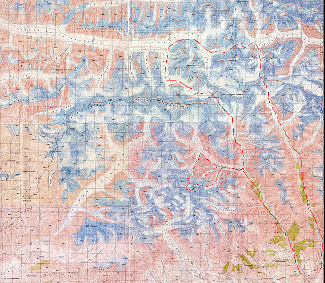
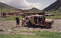
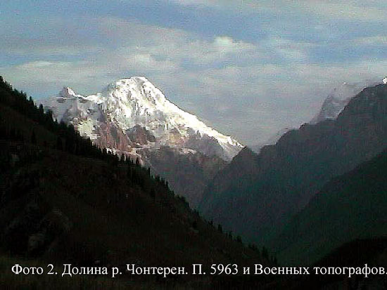
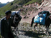
A journey to a lost world or out-of-the-way of Chinese Empire The Expedition “Unknown Tien Shan” Part 1 In contrast to Kongur-Mustagata, where it’s the climbing and tourist boom now there is no any information about that place and it seems there weren’t any tourists. We had only a topographical map, a few black and white photos of that region made by the space station “MIR” and some information about a Chinese Expedition on Tomur from the South side in 1977 and failed expedition of Japan climbers happened a little later. And it took a lot of time to prove the opportunity to get there. And we entirety realized that at worst we couldn’t get any help there should only rely on ourselves. It took us 8 almost raining days and some kind of transport to get Chonteren Glacier: plane to Bishkek and then to Osh, truck to Irkeshtam then to Kashgar along a good asphalt road, train to Aksu (it was “only” 140km from Aksu to the mountains), truck again to Talak, caravan of 4 pack-horses for about 35-40km. The Chinese made a road up to 6m in width exclusively for their ascent on Peak Tomur (Pobeda) in 1977. And the part of our foot-way lay along it. On the border we learned that the Chinese forbade importing meat and spent a lot of time to register in Aksu and to get the permission for trekking in Talak. But it was the good thing to know that it was easy and cheap to stay in hotels, to take a meal, and to hire a taxi in all towns we visited.
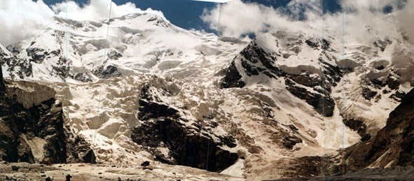
But at last we reached Chonteren Glacier and the unknown world unfolded before us. All cols are still unclimbed there. The route we declared: Talak- Kokyardavan Col (non category)- Chon-Tereksu river- Chonteren Glacier- Cols A 2A-2B from 2nd or 3rd inflows of Chonteren Glacier to 2nd or 1st inflows of Chonteren Glacier- Col B 3A-3B from 2nd or 3rd inflows of Chonteren Glacier to Temirsu Glacier-Col C 3B- Chonteren Glacier- Col D 2A-2B through the spur between Chonteren branches- Chonteren Col + Col via Army topographers 3B- South Inylchek Glacier- Druzhba (Friendship) Glacier- Col E 2B-3A- Tugbelchi Glacier- Col F 2B-3A- Chonteren Glacier-Kokyardavan Col- Talak Because of the circumstances - the weather and a lot of snow on the whole we confined to reconnaissance and the Cols between 1st, 2nd, 3rd inflows of Chonteren West branch and named all cols and unknown glaciers as we liked. The route we done: Talak- Kokardavan Col- Chon-Tereksu river-reconnaissance the exit through the canyon to Sayliksu Glacier- Chonteren Glacier (Base Camp)-food carryings and reconnaissance in upper reaches of Ladybird Glacier- Moraine Glacier- Ladybird Col 3A 5050m radial + Plateau Col 3B 5600m- the middle plateau of Ladybird Glacier, 4500m, - Uyutny (Cosy) Col 3A, 4750m, - Chonteren Glacier (Base Camp)- Chonteren Col 3B, 5488m, - Zvyozdochka (Little Star) Glacier (food carrying)- Druzhba (Friendship) Glacier- Valery Khrischatiy Col 3B, 5200m, -Kichikteren Glacier- Kichikteren-Tereksu river- Coal extraction Industrial Complex. It was the first ascent of All Cols we climbed (excepting Koktardavan Col). As a result we did the obstacles: We made the reconnaissance of a lot of other cols. The Expedition lasted for 36 days including 2days for rest and 2 days for waiting for a better weather. We did 250km. The Team members:
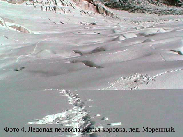
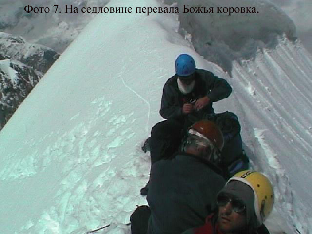
16.07. 1st day of trekking. Kokyardavan Col. We used 4 horses and 4 porters helped us. We did 11km for 2 hours. The weather was sunny. 17.07. 2nd day. Trekking along Chon-Tereksu river. The path was eroded in some places. We did 11km for 6 hours. The weather was sunny with cloud conditions. 18.07. 3rd day. The Base Camp. The path was eroded in some places. We did 12 km for 3 hours 45 min. It was raining all the day. 19.07 4th day. Food carryings. Chonteren Glacier. Different branches. We did 8,4km for 6-11 hours. The weather was sunny all the day but it started raining in the evening. 20.07. 5th day. Ladybird Glacier. We walked on the right bank of open glacier. The open plane glacier lay further. The altitude- 4000m. 5km for 1hour 40 min. The weather was as it was the previous day. 21.07. 6th day. Moraine Glacier. We passed the right bank pocket of Chonteren Glacier. There were moraine, heaps, and conglomerate. Before the turn we climbed on conglomerate to the grassy pocket on the right side. We settled the Camp there. We did 3km for 3 hours. The sky was cloudy. It was raining in the afternoon and it began snowing in the evening. 22.07. 7th day. There was a 40-cm- blanket fall of snow. We had a rest. 23.07. 8th day. Trekking on large- stony part of Moraine Glacier. It was hard to move because of a lot of snow. 3,6 km for 5 hours 55 min. It was sunny day. 24.07. 9th day. Ice-fall. Almost gently sloping part (15-30° ), in some places till 45° . It was too hard to move because of 1m-blanket of snow. 1,2 km for 10 hours. 25.07. 10th day. Under the Col. As last day it was hard to move. We did 1,2 km for 4 hours. By the afternoon we went under the col-raising slope. It was too late to ascend the Col. We decided to settle the camp. The weather wasn’t bad. 26.07. 11th day. Ascent Ladybird Col 3A. Straight to the right (1,2 km-2 hours), upwards the ice-falls, along the snow-ice slope (till 40° of steepness) to the upper circus, then to the left (0,23km- 5 hours). 26.07 11th day. Ascent Plateau Col 3B. We moved up to the right over the ice-fall-cones to the snow-ice slope (40° ), to the upper circus, moved across to the left and reached the (ďĺđĺâŕëüíűé âçëĺň) snow-ice col-raising 45-60° -slope 230m long. The slope was cut by the bergschrund lay across just in the place of leaving to ascend at the altitude 5050m. The sharp like a knife ice-snow ridge (300m) had some cornices. We fixed the rope, organized simultaneous belay, and made 1 pitch. (1 hour 10 min + 50 min). Sunny day. 27.07. 12th day. We fixed 4 pitches climbing the ridge, using snowshoes (0,22km- 3 hours). Before making the snow dome we installed the camp. The weather was sunny. 28.07. 13th day. We roped up and made a final push in bunches to the Col Plateau on the snow-ice slope with ice dumps (till 45° ) (2km-3 hours 15 min) and descent 50m down (15-30° snow slope) to the upper plate (0,8km- 40 min). There was an ice-fall striving down. It was cloudy and then it started snow-storm till the evening. We had to settle the camp. 29.07. 14th day. Descent to the intermediate plate down the ice-fall (30-35° ). There were a lot of ice dumps, clefts, crumblings etc. We moved roped up. We reduced the altitude 1000m down. 2,5km-9 hours. It was cloudy till the afternoon, then the sun appeared. 30.07. Ascent Uyutny (Cosy) Col 3A The Col ice-snow raising 300m-slope (40-55° ). After we climbed 100m we had to fix the rope on the ice-accumulated slope. H4800m. 0,3km-4 hours. Descent to the glacier (1km-4,5 hours). The snow crumbling 45° -slope 100m long extended from the saddle ended with 300-m rock precipice. We fixed the rope to the rock ledge, made a pitch, then traversed to the left up to the snow ridge (25-30m, 40° ), provoked some avalanches, and descended on the snow-rock-ice couloir made 4 pitches, traversed to the left two pitches over the small ridges along the wall, then roped up and descended down and to the left on the 40° -slopes and couloir to the glacier. 31.07. 16th day. Descent to the Base Camp. Closed glacier (roped up), open glacier, the moraine, extended 300-400m down to Chonteren Glacier. Then we went the right –bank-pocket and slopes to the Base Camp (9,6km-5 hours. It was cloudy and raining in the afternoon. 01.08. 17th day. The rest. We should treat Volodya’s leg he injured when he was climbing down. The weather was like a previous day. 02.08. 18th day. We crossed Chonteren Glacier and ascended to the huge grassy right-bank pocket, passed it trough to the rocks in the end to climb down to the glacier. The glacier in that place reared with an ice-fall. So we fixed the rope to climb down 45m the rocks on the right side. Then we moved along the pocket and right-side crumbling along the rock walls. We fond a food carrying and settled the camp near a beautiful lake. 8,4km-5,5 hours. It was a fine sunny day. 03.08. 19th day. Under Chonteren Col, 4255m. We moved along the right side of the Glacier climbing on the grassy pockets. They extended right to the uppers of the glacier. Then descended to the glacier and went along the open ice site to the lower stage of the glacier. We passed it on the left-side crumbling leaded to rock-crumbled-rigel. (9,6km-4 hours 40 min.) Settled the camp. Sunny but it was cloudy after afternoon. 04.08. 20th day. Ice-fall. The gently sloping ice-fall. We moved hard closer to the right side of the ice-falls in Peak Pobeda zone. There were huge breaks there. 2,5km-4 hours 25 min. It was cloudy and then began a snow-storm. And our tent was completely torn. 05.08. 21st day. Trekking to Chonteren Col. There was more snow then yesterday. We moved hard using the snow-shoes. 2,5km-4,5 hours. It became sunny again. But the strong wind arose in the evening. And it began snowing. 06.08. 22nd day. Ascent the Col. The Snow-ice-slope (till 55° ) with a big cornice overhead. We moved hard to up and to the left, fixed the 2 ropes on the avalanche-dangerous place, then made 4 pitches more on the ice-slope to reach the cornice and one rope along it to climb the saddle. (1km-9 hours 15 min). It was sunny weather but there was a strong wind. Descent to Zvyozdochka (Little Star) Glacier. The snow slope (till 55° ) cut by ranktluft, then the hard- blanket of snow slope, then we went round to the right till gently sloping part of the Glacier. (1km-2 hours). 07.08. 23rd day. Descent to Base Camp along the track over the Glacier. (23km-6 hours). A good sunny day. 08.08. 24th day. We had a rest, changed the tent. It was sometimes snowing again. 09.08. 25th day. Trekking to Druzhba (Friendship) Glacier. First we went on the left end of South Inylchek Glacier along the good plane way, pass the ice-fall of North Glacier, went round the ice-fall of South Inylchek Glacier, at the turn of the way we moved to the middle of the Glacier, then along gently slope closed ice we roped up and ascended (using the snow-shoes) the turn to Druzhba Glacier and settled the camp there. (12km-6 hours 10min). 10.08. 26th day. Trekking under the Khrischatiy Col along the right central part of the closed glacier (5km-2 hours). Then we ascended Khrischatiy Col on the snow-ice raising slope (40-45° ) 300-400m long with some bergschrunds, ice falls and a big cornice. We went round the ice-falls on the short steep (till 70° ) places, where we had to fix the rope sometimes. The saddle looked like a wide field. (0,4km-1 hour 45 min). Then we made descent to the plateau. First we dug the cornice in a bottleneck a little to the north of a saddle where was 4m to drop. Then we went the snowy upper part of the buttress (2 pitches), its lower rock-ice part, then we made 9 pitches in the ice-snow couloir ( the steepness 45-50-55° ) (1 hour 45 min). Then we descended the 40-45° - snow on the whole slope, reducing 200-300m at altitude and went to the snow plateau abrupted by the impassable ice-fall. We settled the Camp. (1,5 km- 5 hours). The weather was sunny. 11.08. 27th day. Descent into rantkluft. We crossed the plateau to the crumbling saddle more to the left from the ice-fall and then fixed the rope and made 7 pitches in the upper part of the ice-snow-crumbling couloir (800m, the steepness 30-35° ) then to the left to the rock-crumbling slope and descended into the rantkluft right down the ice (1,1km- 3 hours 15 min). Over the breaks we went to the cones. (40m-1 hour). To move through the rantkluft was very dangerous because of the probability of ice-fallings. We went out the upper plateau to the lower part of the ice-fall (4m of ice in the lower part, 90-100° , then 15m- 40-45° , 1 hour) and began to descend to the moraine. Then we carried separately forward our rucksacks, fixed 30m -rope on gently sloping ice and moved to the left from the rantkluft. Further there was closed, then open glacier torn very much. At first we had to move roped up. Some parts of the route were short (till 60° ) we moved on three steps. Then we went to the right-bank rantkluft and then to the right-bank moraine of Tugbelchi Glacier. (1,5 km- 1 hour 30 min). A Sunny day. 12.08. 28th day. We went under the ice-fall: first along the moraine, then on the ice-slope (20-30° ) (2km-45min). The ice-fall represented as a pile of big crumbled ice blocks seracs of 30° , 4-8m-walls. We climbed up and down, went over open-work bridges with fixing the rope sometimes. (1,5 km- 9 hours). The weather was sunny then it began to be cloudy and finally it started snowing. 13.08. 29th day. We still made the ice-fall. It was like as a pile of unreal seracs and other open-work constructions. We climbed up and down the 4-8m walls (45-80° ), went over open-work bridges. We moved straight and more left to reach the right-bank rantkluft sometimes fixing the rope. Then we moved along the rantkluft and went round the ice-fall to keep to the right side till we reached the ice-dumps. Then went over the ice-fall keep the right side, passed the ice-towers, narrows. Some parts of the route we climbing, some ones were deep in snow, then the ice-fall began gradually planing and we used the snow-shoes. We settled the Camp in the top part. (2km- 8 hours). There was snow and fog that day. 14.08. 30th day. First we went the ice-fall (two more hours), then the closed glacier torn by huge breaks There was a lot of fresh snow, sites of snow-drifts formed by the snow-storm. It was hard to move. (2,5km-3 hours). There was snow and fog again. 15.08 31st day. We had a compelled rest because of fog and snow-storm. 16.08 32nd day. We ascended the Col first over the closed glacier, then hard moving roped up on the rising slope (till 30° ). We fixed the rope to go the last snow-ice part of the route- the steep 20m-snow-ice slope, 45-55° with a bergschrund and a cornice. (3km- 4 hours). Finally we summit the plateau rimmed with immense 300m-ice-rock-chasm (an overhanging glacier). There was an ice-gully in the left edge between the wall and the hanging glacier. And we began to descend on it. The steep of the gully and further of the rock wall was 60-90° . We moved 5 pitches and settle the bivy site. (1,5km- 8 hours). The provoked avalanche took away a rucksack and left a bent ice screw. The weather was sunny again. 17.08. 33rd day. Descent the 100m-Rock-Wall, 70-80° (3 hours), then the 45-30° snow slope (1,5km- 40min). Then we went the closed glacier with gradually rising steep and the ice-fall we turned over the left-bank rantkluft, avalanche cones and went on the left-side moraine. We descended the moraines and left side crumbled slopes and went on the left side pocket- a good place for the Camp after the night in a sitting posture. (1,8 km- 50min). The sunny day was again. 18-20.08 34th –36th days. We descended the left side moraines, went the track along the left bank of Kichik-Tereksu river, over bridges, crossings ford… The track was hard, often getting lost with a lot of by-passes of eroded parts. This track leaded out to the Coal extraction Industrial Complex. (50km- 245hours). The sun saw us home. Descriptions of the Cols, the Ascents Glacier- Ladybird Col 3A 5050m radial, first ascent
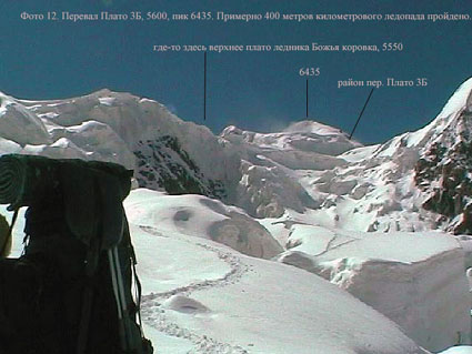
It is situated in a Southern spur of a Kokshaaltau range dividing the Chonteren and Temirsu glaciers, in east spur at the altitude 6435m. It connects from the north –Moraine Glacier (the inflow of the western branch of Chonteren glacier), and from the south- Ladybird Glacier (the inflow of the western branch of Chonteren glacier) It has done radially for the first time. Descent to the south is reconnoitered. It has passed from the north. The description is given from a grassy pocket of the right board of Chonteren glacier on merge it to Moraine Glacier. Ascent. Part 1. On the right-bank pocket (the large-stone moraine filled up with a snow, then on the covered glacier we climbed up to the closed part of the glacier. A part of the moraine covered with snow blanket, we bypassed on slopes of the right board, whence avalanches went almost continuous stream. 5 hours 55 min.
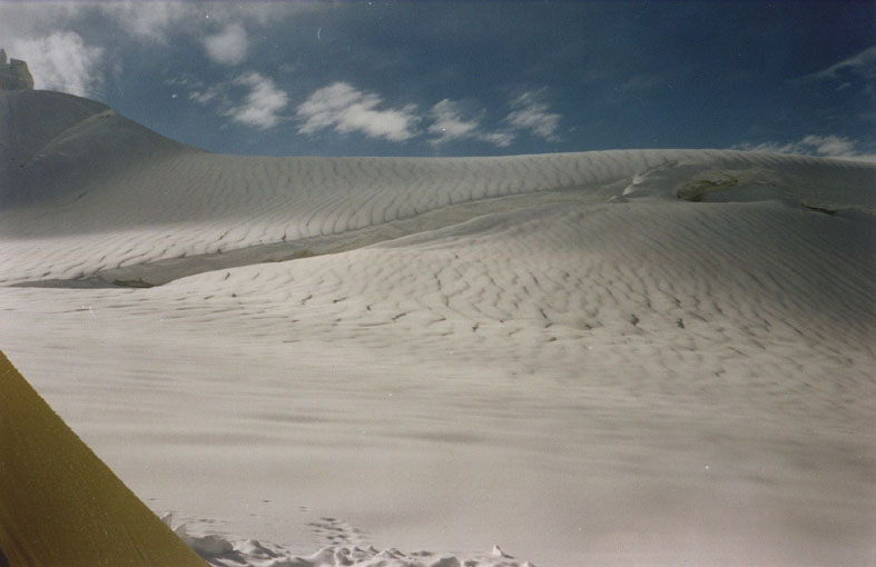
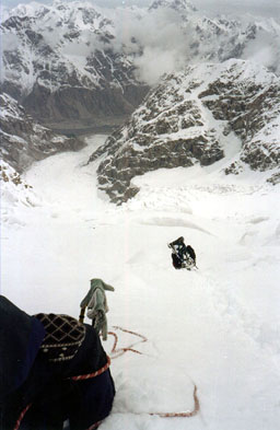
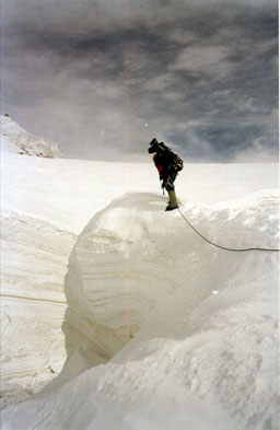
Part 2. The closed glacier (roped up), further flat (15-30 degrees) but strongly torn ice-fall covered with snow blanket. Heavy moving. To Ascend the uppermost circus of a glacier in the top part we went on cones of ice collapses and sites of naked ice. The ascent went a little more to the right on a course of the big cone of an ice collapse up to a plateau, further we untied and we crossed a cone to the left headed to the col-raising slope. Before it - a site of a deep snow. 16 hours 35 min. The col-raising slope is cut with a bergschrund, extent of 300-350 m, a steepness of 45-60 degrees, in the top part - snow cap of 60-65 degrees which it is not clear how it keeps on the ice.
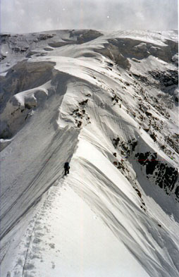
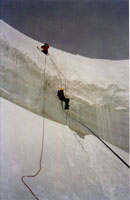
Part 3. Ascent went along an abrupt snow crest, on ice (you have to fix the rope), along rocks. To climb the output on a saddle you should go through snow of any mad steepness - in snowshoes, obliquely, to get out simply in crampons it was not possible. It took us only 7 pitches. According the steepness it corresponds 3Ŕ-category. 5 hours.
The saddle- Narrow (on a foot) a snow ridge with the cornices overhanging on the south. It is possible to spend the night, but it would be hard (we had to dig the ridge till width of a stove bench, normally to put tent it is impossible). The note. Comprehensible descent from this saddle on the south is not present- it is necessary to pass on a sharp ridge to lower, east saddle. If to plan a through passage for Ladybird glacier it is better to rise from Moraine Glacier on lower saddle if thus you are ready to pass enough abrupt but short rocky belt. Snow-rock-crumbling couloirs leave from this saddle on Moraine Glacier. And it demands to work with a rope. So the difficulty of the through passage - 3Ŕ. The General time of passage- 27 hours 30 min. (Two days) Time of ascent- 27 hours 30 min. Plateau Col 3B 5600m, first ascent
It is situated in a Southern spur of a Kokshaaltau range dividing the Chonteren and Temirsu glaciers, in east spur at the altitude 6435m. It connects from the north –Moraine Glacier (the saddle of Ladybird Col, the inflow of the western branch of Chonteren glacier), and from the south- Ladybird Glacier (the inflow of the western branch of Chonteren glacier) It has done for the first time. The passage was from the North to the South. The description is given from a saddle of Ladybird Col to an Intermediate plateau of Ladybird Glacier. The name is given to destination col - it provides some variants of an output on the top plateau of Ladybird glacier, with possible passage is farther than several cols on glaciers Temirsu and others. It allows to leave on an intermediate plateau of Ladybird glacier under Uyutny (Cosy) Col, around of 600-meter bottom almost impassable ice-fall of Ladybird glacier. From the col it’s possible to make a simple beautiful ascent up to 6435m. Ascent. Part 1. Narrow (on a foot) a snow ridge with the cornices hanging down on the South. We moved roped up to the beginning of an abrupt site of a ridge. Here we settled the camp.
Part 2. We fixed the rope and went a snow-ice-ridge with a steepness up to 40 degrees which leaded on a wide part of the ridge (snow fields), steepness of 15-30 degrees. We roped up and went the ice cornice in the top part of the ridge, we bypassed it on the right on a course, then went direct along the cornice (up to 45 degrees, ice), and climbed higher to the right upwards, around of the big bergschrund, then after the bridge – there is a wide snow ridge on the left of it- a saddle of the col. 6 hours 55 min.
The saddle - The Wide snow ridge with the sites of cornices which are hanging down on the South. It is possible to spend the night there, but you can be blown off, you will better go down on the top plateau. Descent. Snow slope of 10-20 degrees, about 200 m, further the plate plateau breaking downwards by a kilometer (1000 m - difference of heights) ice-fall, movement basically roped up, here and there descent to three steps, in the top part of the ice-fall we passed fixed the rope and made one pitch. To pass the ice-fall you should keep the the centre of the right part, then in the bottom part – should be closer to the right board, in several places – should move through the zone of ice collapses. 9 hours and 40 minutes.
The note. With passage of the second step of the ice-fall (600 ě) the route considerably becomes complicated, probably, will turn out 3B*. The General time of passage- 17 hours 45 min. (Two days) The Time of ascent- 8 hours 05 min. Time of descent - 9 hours 40 min. Time of movement with the belay- 17 hours 45 min. Points of the belay- (snow/ice)- 8
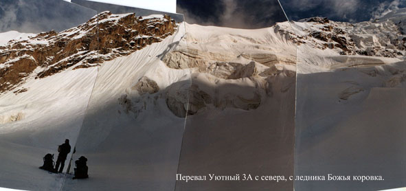
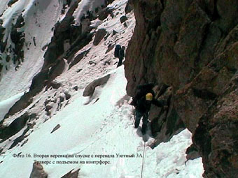
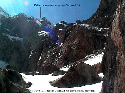
Uyutny (Cosy) Col 3A, 4750m , first ascent It is situated in a Southern spur of a Kokshaaltau range dividing the Chonteren and Temirsu glaciers, in east spur at the altitude 6050m. It connects from the north –Ladybird Glacier (the inflow of the western branch of Chonteren glacier), and from the south- Uyutny (Cosy) Glacier (the inflow of the western branch of Chonteren glacier) It has done for the first time. The passage was from the North to the South.
Ńol-raising slope – snow-ice slopeof 300m, 40-65 degrees, cut with a bergschrund
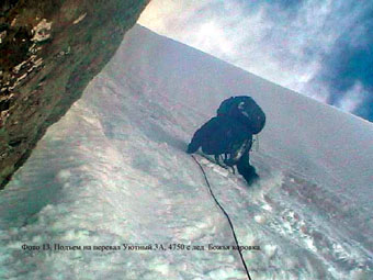
Ascent. Part 1. From a camp we climbed on the closed glacier and avalanche cones moved to a bergschrund. Further we went 100 m over the bergschrund- (roped up), then fixed the rope and ascended on tough ice-accumulated slope. The saddle is rimmed with a snow cap riveted on rocks. 4 hours. The saddle- A quite narrow snow ridge with rocky fingers sticking out of it. A rare case when on a saddle it was possible to put stones toghether a little upper on the rocks. The Camp theoretically is possible. A short (about 100m) snow-crumbled slope leaves on the south breaking 300m-rocky dumps.
Descent. Part 1. From the saddle we fixed the rope and descended right down on the snow-slope, 45m, 35-40 degrees (the loop was fixed on the rocky finger). The first climber provoked a snow layer moving. Then we fixed the loop on the rocks and moved to the left upwards 20-30 m up to a snow ridge, with a snow-rock-ice-crumbled couloir. First we made some avalanches downwards, cleaning a slope. The couloir- 40-45 degrees. We descended 4 pitches, fixed the rope on ice screws, rock ledges, and moved the the last one with belay.. Further ahead there were the similar rocky dumps, we traverced two pitches to the left along a rocky wall to the next couloir with rock-sites. Then we descended roped up to the left downwards crossing some buttresses, mainly on a crumbled site, sometimes rocks, snow sites, and went out finally on a left-bank moraine of Uyutny (Cosy) glacier. We settled the Camp under a huge stone where there was no snow. 4 hours and 30 minutes.
Part 2. We went first on the closed (roped up) and then open Uyutny (Cosy) glacier, went keeping the left side. After achieving the tongue of the Glacier we untied and we passed open ice, moving ahead closer to the center of a valley. Further we went on enough powerful river, along the left bank we went to abrupt (40 degrees) konglomerat-crumbbled (a talus with big stones) slope, and along the river we went down in a pocket of the right board of Chonteren glacier. 5 hours. The note. With passage of the second step of the ice-fall (600 ě) the Col considerably becomes complicated, probably, will turn out 3B. The General time of passage- 13 hours 30 min.
(Two days) Points of the belay- (ascent, ice)- no less than 8, (descent, rock-snow-ice)-3/2/5. |
||||||||||||||||||||||||||||||||
| © 1999-2007 Mountain.RU Mail to: info@mountain.ru |
|