On July, 11 - September, 08, 2004 a complex
expedition organized by Moscow Federation of Mountaineering and Rock-climbing
(MFMRC) and Sports Club of Moscow Aviation Institute (МAI) aimed to summit the
highest peak of China Pamir and Kun-Lun - Kongur, 7719m, North face, via
a new route will take place.
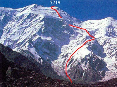
Kongur, a view from the north.
A general view of the route, altitude difference of 4000m.
Expedition team consists of 17 high-altitude
climbers (MFMRC) and mountain tourists (MAI club).
The head of the complex expedition is Jury Hokhlov,
the head of MAI tourist command - Andrey Lebedev.
The expedition set to lead a new route
to Kongur summit from the north. In addition the tourists plan to do that within
the framework of a mountain campaign of the highest category of complexity.
The first Russian expedition on Kongur
was organized by Moscow Federation of Mountaineering and Rock-climbing in
1998. Since then the team have repeatedly visited Kashgarskie mountains. Almost
all its members summited the third highest top of the area - Muztagh-Ata (7546m).
In 2002 and 2003 the team tried to summit Kongur, first via the north face,
then from the southwest, however the mountain did not want to surrender. The
team has perfect conception about the area, weather character and conditions
of ice-snow top cover.
MAI Tourist Command has repeatedly won
National championship on extreme mountain trekking of the highest category
of complexity (1990, 1999, 2001, 2003). In 2000 it carried out the independent
mountain campaign in mountains of China for the first from Przhevalsky time.
The team has in its active unique 470-kilometer trekking "Pamir marathon" (1999)
with ascents on peaks of Revolution (6974) and Lenina (7134) and 370-kilometer
"Zaaliysky marathon" (2001) with first ascent on Beleuli peak (6065) and traverse
of Lenina peak.
Complex
expedition of Moscow Federation of Mountaineering and Rock-climbing
(MFMRC) and Sports Club of Moscow Aviation Institute (МAI) on Kongur
(7719m) (Kun-Lun Shan Mountains, China Pamir)
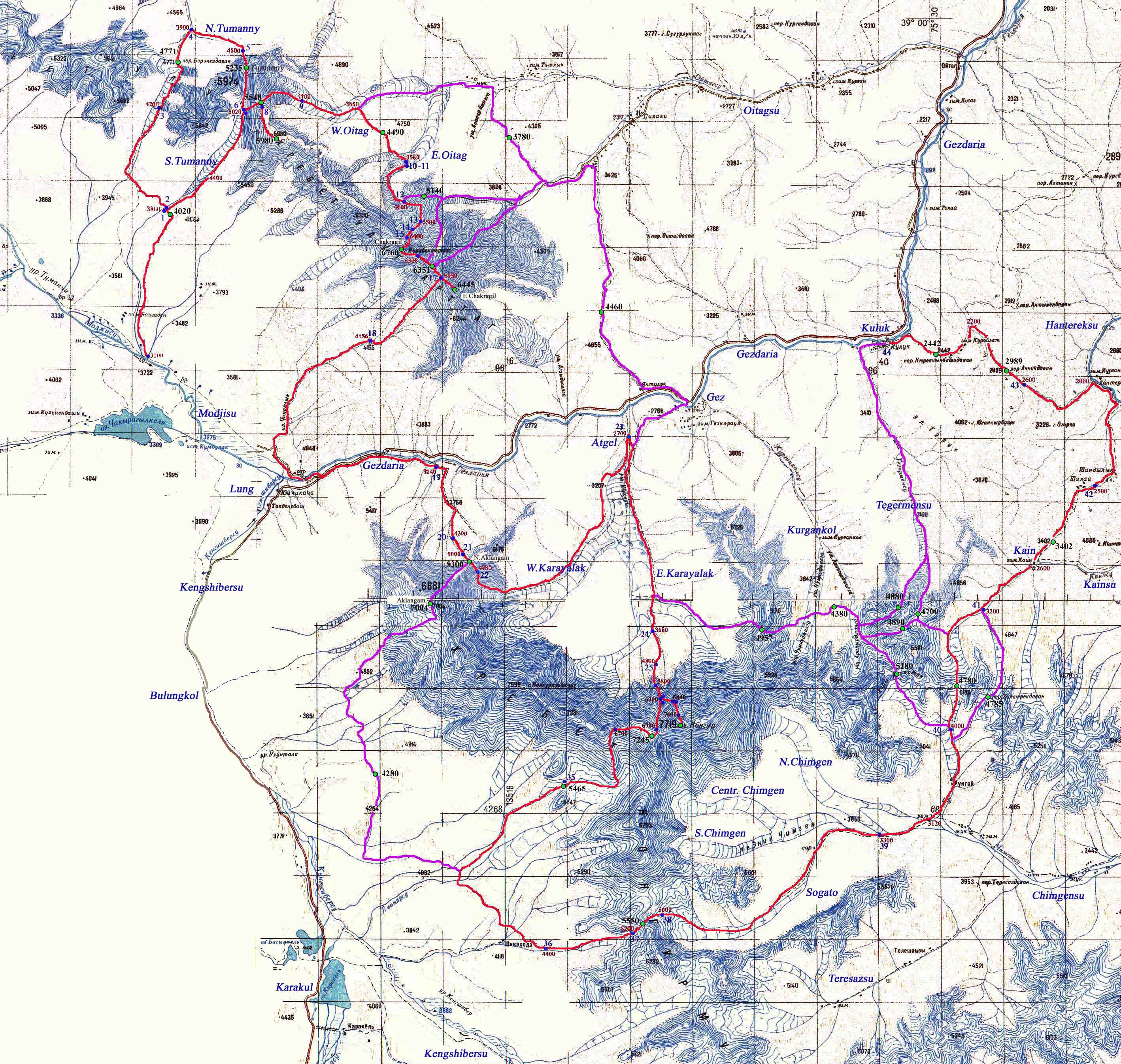
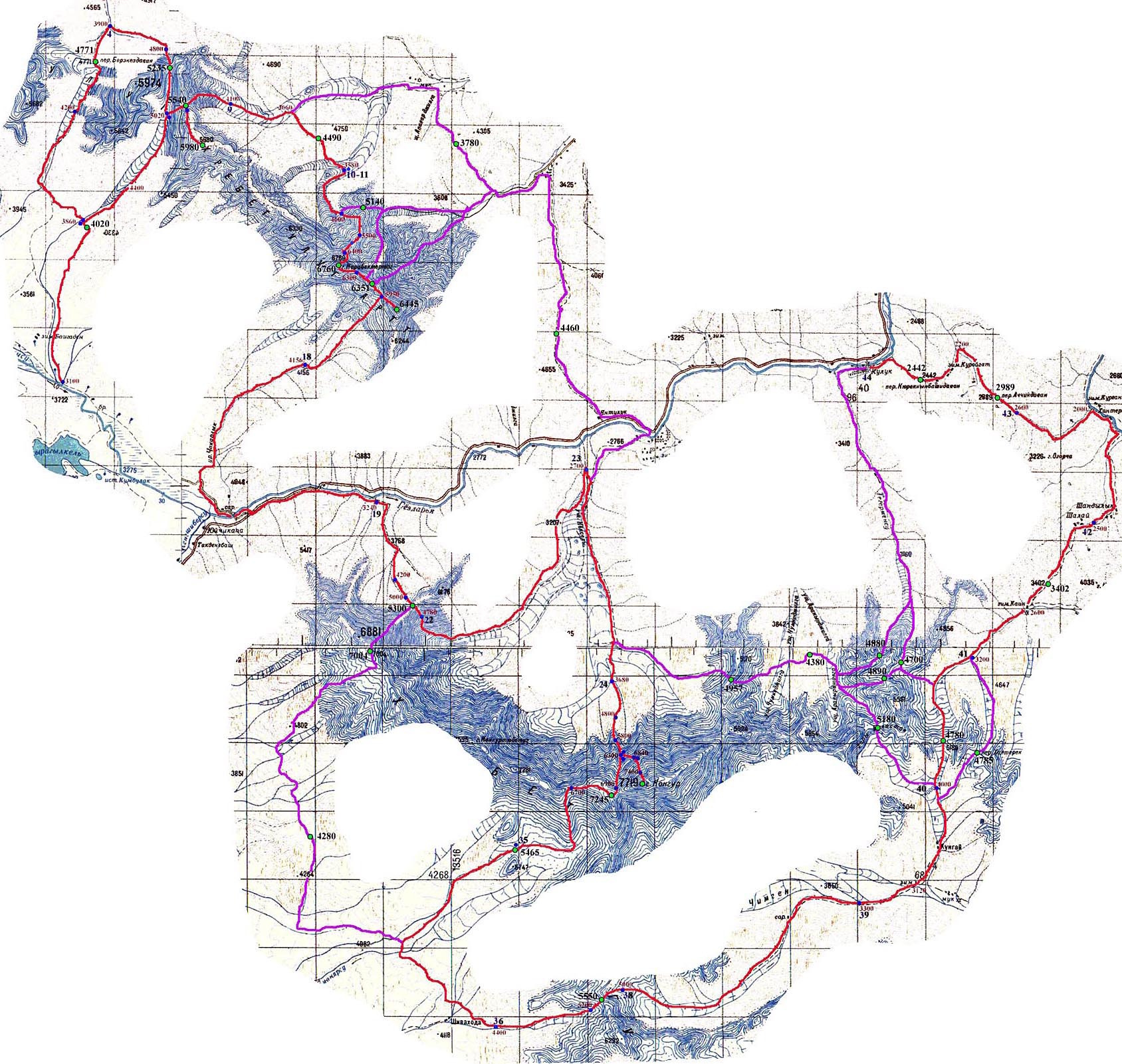
The route line: Modzhisu river -
Berekezdavan pass (4771m,1B) - Tumanny (Foggy) pass (5235m,3А) -
pass of 5440 (3А, first ascent) - peak of 5980m radial - pass of
4490m (1B, first ascent) - traverse of Chakragil peak, from the
northeast to the southerneast ridge (6760,3B, first ascent) - Verkhny
Chakragil peak radial (6445m) - Gez river - South Aklangam pass
(5300,3А) - Karayalyak glacier - Kongur peak radial via South-West
face through a plateau of 6046m (7719,3B) - Karayaljak pass (7245,
3B, first ascent) - Bonnington pass (5465,2B) - Karakul lake valley
- 5550m pass (3А, first ascent) - Sogato glacier - West Khanterekdavan
pass (4780,2A, first ascent) - Kainsu river - 3402m pass (n/c) -
Khantereksu river - Achchikdavan pass (2989,1А) - 2442 m pass (n/c)
- Kuluk settlemeent